Posts

Showing posts with the label PDS Tornado Watch

Tornado Watch Summary; Updated 6:25pm

Image
6:25pm These are rare and should be seriously considered in your plans into this evening.  3:55pm, a new tornado watch issued.  4:24pm Please get your shelter ready! If you live in a mobile home, you can find your nearest public shelter here . 

New Tornado Watch: Issued 8pm EDT Saturday

Image
Tornado Watch until 4am, it includes Birmingham, Atlanta and Mobile.  This watch is in effect until 1am. Please make sure you have a weather radio or other system that will awaken you if a tornado warning is issued.  We now have "particularly dangerous tornado situation" tornado watches in effect for parts of Louisiana, Mississippi and Alabama. While the second and third in 12 hours, this type of tornado watch is rare. Note that "numerous strong tornadoes" are forecast to occur.  If you live in these areas, it is essential that you follow the latest weather information and  that you are prepared to go to your tornado shelter immediately if a warning is issued. If you need to clean or declutter your shelter area, do it now.  If you live in a mobile home, I suggest you see if you could spend the afternoon with a friend or relative in a conventional home. Know where your community shelter is located; map and list here .  Shelter recommendations: Today's o...

"Particularly Dangerous Situation" Tornado Watch - Update 10:45pm

Image
This deserves a posting of its own. A very rare  particularly dangerous situation (PDS) tornado watch has bene issued from now until 3am. As of 10:45pm, unfortunately, this forecast looks like it will be extremely accurate. Please continue to monitor the weather until 3am if you live in these areas.  "Strong" tornadoes are likely along with 80 mph winds and tennis ball-sized hail. I don't recall ever seeing a PDS watch being issued at this time of night without a PDS watch earlier in the day.  If you live in a mobile home, be prepared to go to a friend or relative's conventional home or a public shelter to spend the night. You will find detailed information on public shelters  here .  I also highly recommend the  StormWar n telephone call warnings. You are called only if you are in a tornado warning or warning for 80 mph or stronger winds at  your location. 

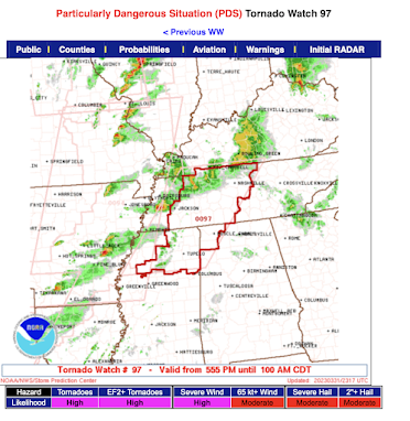
PDS Tornado Watch: Tennessee, Mississippi and Alabama

Image
This "particularly dangerous situation" tornado watch is in effect until 1am and includes Nashville, Muscle Shoals and Tupelo. A supercell that has caused strong tornadoes is now northeast of Memphis and is moving toward Middle Tennessee. Here is the radar at 6:21pm.

Two PARTICULARLY DANGEROUS SITUATION Tornado Watches

Image
4:30pm: In addition to the two tornado watches below, there are tornado watchers for northern Illinois (including Chicago) and southern Wisconsin (including Milwaukee).  Particularly Dangerous Situation (PDS) tornado watches are rare. There are entire years without one. To get two simultaneously further signals just how dangerous situation situation is. Right now, former President Trump is the lead story on the national news. I believe that it will be tornado damage tomorrow morning. Now, we need to keep the death toll as close to zero as possible.   In addition, wind gusts of 70 mph and hail the size of apples are forecast to occur. At least scattered power outages are likely. This may be the worst day of tornadoes since 2011. If you live in a mobile home and you are west of the Mississippi River, now is the time to seek other shelter (unless your mobile home park has one you can access quickly).