
3:45pm EST Friday: Tropical Storm Ophelia Strengthening
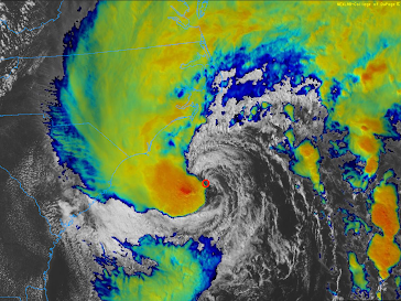
Red "O" is the center of Ophelia Based on both data from a Hurricane Hunter aircraft inside the storm plus the latest satellite imagery, it appears that Ophelia is strengthening and hurricane intensity before landfall is not out of the question. One of the signs of a strengthening storm is lightning near the center. There is considerable lightning at this time. Hurricane Hunters are showing both stronger winds and the lowest barometric pressure has dropped about 4 millibars since 11am. If I were living near the North Carolina coast, I would be monitoring the progress of this storm. Remember, there is a storm surge warning for the North Carolina coast and there is a risk of tornadoes of tornadoes tonight in addition to strong tropical storm force winds.
