
An Unwarnable Tornado
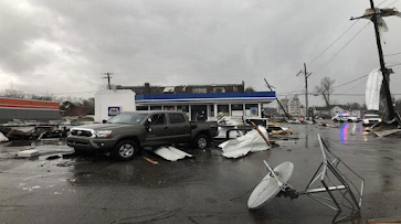
WBKO Over the history of this blog, and elsewhere , I have written about obvious tornadoes that were not properly warned and how the trend the last decade has been in the wrong direction. It is something that weather science needs fix on a high priority basis. Saturday, however, was the type of tornado everyone dreads: the unwarnable tornado. It struck Hopkinsville, KY at about 9:24am New Year's Day . There was no tornado watch and no tornado warning. National Weather Service The damage was substantial on the east side of town. I expect the tornado to be rated EF-2 based on the photographs I have seen. To see why this tornado was unwarnable, let's look at the radar images. This first image, from 9:22am, will orient you to the overall situation. This is two minutes before the tornado struck. On the left is the reflectivity data, the type you see on television. On the right is the Doppler wind data which meteorologists use to find rotation within thunderstorms. Th...