
The Truth of The (Non-) Warning of the Eureka, Kansas, Tornado
I was disappointed shortly after 5pm this evening when I watched KAKE TV, a Wichita TV station, host a National Weather Service meteorologist who told the people of Eureka, Kansas, and his wider audience, several things that were inaccurate when it came to the reason they did not issue a tornado warning before the EF-3 (strong!) tornado struck.
The Background
This was a poor performance by the NWS considering it was an EF-3 tornado. There no tornado warning. There was neither a tornado watch nor a severe thunderstorm watch. I am going to focus on the lack of a warning.
Points made during the KAKE interview along with my rebuttal:

 |
| KAKE TV, damage in Eureka |
This was a poor performance by the NWS considering it was an EF-3 tornado. There no tornado warning. There was neither a tornado watch nor a severe thunderstorm watch. I am going to focus on the lack of a warning.
Points made during the KAKE interview along with my rebuttal:
- "The radar operates at five minute intervals, so we couldn't see the tornado spin-up." The radar has the ability to operate in the "SAILS" mode which will allow them to view the storms has 1.2 minute intervals -- four times more frequently.
- "The spin-up couldn't be anticipated." There had already been a tornado in Butler County, the county immediately to the west. The Significant Tornado Parameter was "2", above the threshold of one (see below). Both should have alerted them to the danger.
My conclusion: A warning should have been issued before 7:15.
Below is the data so those who are familiar with these situations can make up their own minds.
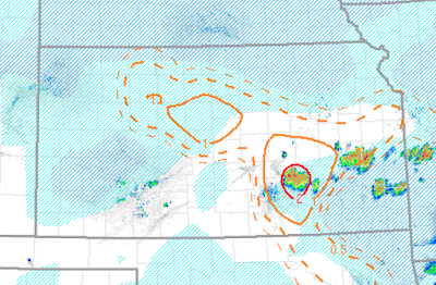
Significant Tornado Parameter Available One Hour Before the Tornado Touched Down

The storm in question is within the red "2" value.
The Earlier Tornado to the West

This was a statement issued by the National Weather Service in Wichita 38 minutes before the Eureka tornado.
The Doppler Radar Data
I am not annotating the data because I don't want to cover up the data with the annotations. Click to enlarge. The Doppler wind data is on the right and the (developing) tornado is where the greens and reds come together.
 |
| 7:01pm. Rotation clearly developing along US 54 west of town. |
 |
| Skipped an image to save space. The rotation is tightening west of the city. There is clear rotation seven minutes before the tornado touches down. |
 |
| Clear indication of a developing tornado. |
 |
| Tornado on the ground in east Eureka. The yellow/green is the tornado. |
 |
| Tornado northeast of the city. Second area of rotation over Eureka. |
I believe that any trained, experienced meteorologist would come to the same conclusion: a tornado warning would have been possible prior to the tornado touching down.
In addition, during the KAKE-TV interview, it was said by one of their meteorologists that the Joplin Tornado spun-up in a couple of minutes. Incorrect! I cover that in my book, When the Sirens Were Silent.
Hopefully, we can learn from this event so it does not happen in the future.


Comments
Post a Comment