Posts

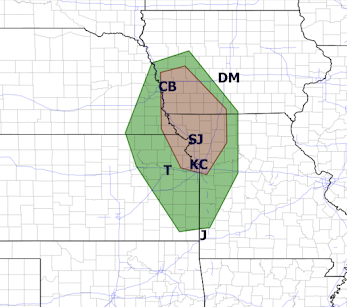
Tornado Watch: MO, KS, IA, NE

Image
No sooner did I finish with updating the tornado and wind forecast (below) than a tornado watch was issued. The tornado watch forecasts until 10pm: Tornadoes Hail up to 3 inches (!) in diameter Damaging winds of 70 mph I also believe there is a good chance another watch (or more) will be issued for areas to the south of this watch as the evening progresses.  As of 3:43pm, thunderstorms are rapidly developing in eastern Nebraska and are moving southeast.  I'm worried about this one. Please keep an eye on the weather if you are in the tornado watch or if you are in the tornado or damaging wind areas in the forecasts posted immediately below.

Tornado and Damaging Wind Forecast

Image
Here is the tornado forecast from 5pm to 5am. The brown area has a significant risk.  And, here is the damaging wind ( >60 mph) forecast. Red = elevated risk.  Yellow = significant risk. If, by chance thunderstorms develop in the green area in Kansas, they could produce extreme winds.  Put the car in the garage and put trampolines and outdoor furniture indoors. Power failures are possible.

Thank You: Fox 4 Kansas City's News Report on the Tornado Warning Issues

Image
I would like to thank Dave D'Marco and Fox 4 Kansas City for following up on the missed tornado warning in Kansas City and for including me in their coverage.  There are two comments I would like to make about the NWS's remarks: Meteorologists at the National Weather Service early Wednesday morning weren’t expecting tornadoes to form as storms moved into the area. They were told to expect tornadoes by their own tornado forecasters at 10:15. See below: Next: But Adolphson [the meteorologist in charge of the Kansas City National Weather Service] said it’s not that simple to detect and there are others factors at play. “You don’t want to be issuing on every one of those little circulations that you see because you are going to be alerting upwards of a million people in the middle of the night who will not have virtually any impact,” she explained. You do want to issue a warning if that "little circulation" is joined by lofting debris!! The combination of a circulati...

A Rite of Passage For the Children of Tornado Alley

Image
So glad that he went back to bed easily after the tornado had passed.  During her first tornado warning, one of my granddaughters crawled into their dog's kennel . 

This Month's REQUIRED READING

Image
I hope that Ted Nordhaus is correct. He writes ,  click to enlarge Ted also states, "the post-Ukraine energy emergency is likely to accomplish much that the climate emergency could not. The environmental movement's fetishizing of regulatory solutions and it arbitrary technology preferences have always hobbled its ability to advocate for effective climate politices at the scale needed to have much effect on warming. Ironically, decentering climate and centering energy security, particularly in the West, is likely to do far more to address climate change than the climate movement could have have accomplished." Amen, amen!! While a bit long, the article makes many excellent points. It long past time to get serious about energy production and engage in a crash program to install nuclear and, where practical, hydro power across the United States. We also need to "drill, baby, drill." I have two quibbles with Ted's article:  1) it is storm warnings that are saving...

I'd Be Honored If You Did...

Image
You may order or get more information here . 

Updated Damaging Wind Forecast

Image
The NWS SPC has changed its damaging wind forecast as compared to the one earlier today (below). The area around Wichita and central Kansas has been taken out of the 75+ mph forecast and the threat in west Texas and Oklahoma has been raised. The updated forecast's hatched area is for wind gusts of 75+ mph and the new red area in the Panhandle and Oklahoma is for a higher risk of damaging winds actually occurring.  Please prepare accordingly!