Posts

Drought: A Small Ray of Hope?

Image
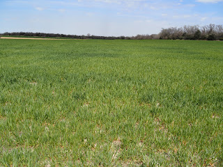
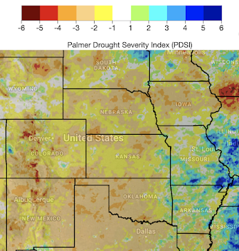
Wheat field, April 16, 2022. central Butler County, Kansas I went out to take a look at a few wheat fields myself this afternoon and the crop probably looks the worst I've seen it in my 40+ years. While I am certainly no expert, the reports of poor crop conditions appear to be correct. Over the next two weeks, the extended range computer models are indicating the possibility that sufficient rains may fall that could slightly ease the drought in the winter wheat belt. How Much Rain is Needed? Based on the Palmer Drought Index, the following amounts are what are needed to ease  the drought. Note: these amounts are in addition  to the "normal" rainfall amount (i.e., if normal is 2 inches and the map shows 3 inches, then 5 inches are needed). NOAA has helpfully calculated the amounts needed. The black areas had insufficient data to make an estimate this week. The states are broken into NOAA's "climate divisions."  The Forecasts Among the products produced by the...

The Blizzard Was As Bad As Forecasted

Image
AccuWeather More than five hundred miles of Interstate 94 was closed for more than three days. It will be days before the area gets back to normal. You may with to consider not traveling to North Dakota or eastern Montana at this time.  Here is the final picture of the amount of snow that fell. Of course, that does not include the height of the drifts. Wow!

Tornado Drought: Ten Years Since the Last Major Tornado Outbreak in Tornado Alley

Image
Ten years ago yesterday, strong tornadoes roamed the Great Plains. The photo below is from my blog post ten years ago today . This is a map of the paths of the tornadoes.  The Tornado Outbreak of April 14, 2011.  Red = tornado. Blue = damaging thunderstorm wind. Green = large hail. Yesterday was the tenth anniversary of the last major tornado outbreak in the area we traditionally label "Tornado Alley." Of course, the reality is that the peak tornado alley moves through the decades .  But, even stipulating that tornado alley moves, it is extremely unusual that we have had such a drought of major tornadoes of this duration and I am concerned that a number of us have forgotten how to prepare for a high or extreme-risk tornado situation. For reminders, please go here and scroll down. It is vital that we residents of the Great Plains not let down our guard. As the situation Tuesday in Texas and Iowa demonstrated, strong tornadoes will occur again and the tornado drought will ...

Update on Moisture for Winter Wheat Crop

Image
Here is the Palmer Drought Index based on data through April 5. The drought has enlarged throughout the wheat growing area up to April 5. Since then, light to moderate rain has fallen in the area. For the next 15 days, an ensemble of rainfall amount forecasts from the European global computer model shows mildly below normal amounts in Kansas and near normal amounts in Oklahoma. Below is the European forecast's departure from normal rainfall amounts.  

A Review of the 3-Day Tornado Forecast

Image
Much of the eastern half of Kansas has been in a tornado drought. So, I worried that people were out of practice when it came to dealing with major tornado threats. So, I made the first-ever (for this blog) 3-day advance forecast for the tornadoes that occurred Tuesday (12th). Because I urged readers to take preparatory action, it is only fair that I review the forecast as it was not a success. The Forecast The forecast was for "strong" tornadoes which meteorologists define as EF-2 or greater. Because the high risk area (red) has been nearly tornado-free the last five years, I wanted to give readers plenty of time to prepare.  What Actually Happened Red = Tornado. Blue = Damaging thunderstorm winds. Green = large hail. There were strong tornadoes in both Iowa and Texas. The image below, from CBS Austin (via Twitter), was of the Salado, TX tornado's aftermath. But, with the exception of the tornadoes in southeast Nebraska, the tornadoes were outside of my highest risk area...

Dangerous Period Starting This Afternoon

Image
As we get into the afternoon, a really dangerous situation is setting up.  If you live in the orange or red area, it is essential  to keep track of the latest weather information. The risk of tornadoes and wind gusts stronger than 75 mph is very high. 

Today's Tornado and Damaging Wind Forecast

Image
Another day of violent weather across the nation.  Tornadoes The brown area has a significant risk of tornadoes. The yellow area has an enhanced risk of strong tornadoes.  The red area has a high risk of strong tornadoes. Damaging Winds The purple area has an extreme  risk of wind gusts above 75 mph.  The red area has a high risk of wind gusts above 75 mph. The yellow area has an enhanced risk of wind gusts above 60 mph. Power failures from last night's storms: As you can image, there is a high  risk of power failures in the red and purple areas. Prepare accordingly! Make sure friends and relatives who are infirm are cared for. Fill cars with fuel. Extra cash from ATM. Charge laptops, etc., but disconnect them when you hear thunder. Throughout these areas, please monitor the weather throughout the day.