Posts

Showing posts with the label Southwest

The Growing Drought Danger - Updated

Image
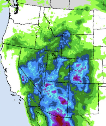
Saturday: The item below is from Twitter/X and was published by Dr. Ryan Maue who is a meteorologist and the former chief scientist of NOAA. I share his concern. As I mention below, I would be putting proactive water conservation measures in effect now, just in case.  -- The information below was published Thursday --  We try very hard to make this a "no hype" site for weather forecasts and other information. With that said, my concern is growing by the day that we are in for serious and worsening drought in the western half of the "Lower 48." The map above is the difference from average forecast temperature for the next five days. From California to the Rockies and High Plains it is forecast to be very warm. This is an "ensemble" of forecasts from the ECMWF model system (which tends to dampen out forecast extremes as we get farther into the future) and it continues to show significantly warmer than average weather in the same area. With greater heat, high...

Thunderstorms and Flash Flooding Likely in the Southwest

Image
Unusually heavy rains -- generally from thunderstorms -- are forecast across the Southwest. The remains of Hurricane Mario will be drawn into the region which will enhance rainfall amounts. The map shows forecast rain from now until Sunday evening. Cloud-to-ground lightning will also be a hazard.  It is important for residents and travelers in the Southwest to keep an eye on the weather the next few days. 

6:15pm: Southern California and Southwest Rain

Image
These are extraordinary amounts.  Radar at 4:17pm.  More heavy rains have fallen over the Los Angeles basin today.  At 2pm, UCLA's weather station has received about two-thirds of that (11.82") in just the last 24 hours! Normal for the year is 17.73 inches. UCLA is in the west LA suburb of Westwood. This is truly an extraordinary storm.  --- original posting --- Important forecast information from Noon Above is the additional forecast rainfall from now until 10am PST tomorrow.  This is the additional forecast for 10pm Wednesday.  This heavy rain across the Southwest, especially in Arizona and New Mexico, will ease mild to moderate drought conditions. However, it will cause additional serious flooding in California.  As of 1pm, radar shows the rain associated with the atmospheric river extending from the California coast to northern Utah.  The flooding in the Southland will get worse before it gets better. Another slug of heavy rain is moving acr...

Some Improvement in Southwest Drought

Image
Rainfall Forecast for the Next Seven Days The Southwest Monsoon has been unusually early and its rains unusually heavy so far this summer. And, that is helping with the drought. The above map is forecast rainfall amounts for the next week.  Below is a map of the rainfall deviation from normal during the past two weeks. As you can seen amounts have been quite heavy.  While these heavy monsoon rains will not help California much, they will help Utah, Colorado, Arizona and New Mexico through at least the next six to ten days.