
Hurricane Lee Update, 4:50pm Sunday
Here is the latest forecast, out to five days, from the National Hurricane Center.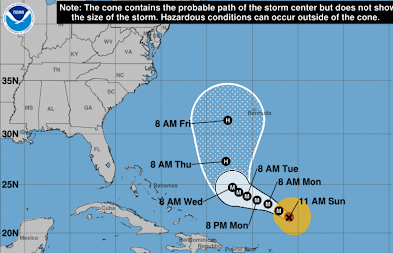 In spite of what you are hearing in the media, there is zero chance of a U.S. landfall before Saturday and, if a landfall occurs, it will likely be late next weekend. There is also nearly zero chance the eye of the storm will pass over New York City in spite of what CBS and other outlets have written.


Thanks to Tomer Berg, here is a combination of all of the models and the likelihood of the eye passing over a given location.

When Lee gets to the latitude of New England and the Maritimes, it is likely it will become a Hurricane Sandy-type storm where high winds will spread out over a vast area several hundred miles across. It is probable, the peak winds at that time will be 100 mph or less -- just like Sandy.
Of course, all of this regarding landfall is highly speculative. I'll start my coverage Tuesday night or Wednesday morning. Please stay tuned.


Comments
Post a Comment