10:50pm Update on Ophelia
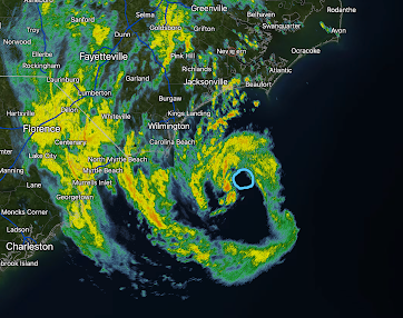
Radar of Ophelia at 10:46pm. Blue = eye. It is moving north northwest at 12 mph.
Winds are still 70 mph even though pressure has dropped to 984 millibars. There is still a chance it will officially reach hurricane force (75 mph) before it makes landfall early Saturday. There is considerable flooding due to the deepening storm surge. High tides will be after midnight, so dangerous flooding is likely in coastal areas.
Tornadoes are likely during the night in eastern North Carolina.


Comments
Post a Comment