Posts

BULLETIN: 9:15pm Helene Update

Image
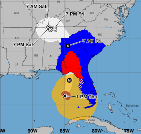
Rare "extreme wind warning" issued. Radar at 8:57 shows the position of Helene. I've drawn a "donut" around the eyewall.  The highest winds are within the "donut" with the very highest winds in the northeast quarter. We are within an hour of the eyewall getting to land. Gusts will be at least 150 mph in this very dangerous storm.  At 9:07pm, Doppler radar measured a 160 mph wind at about 5,000 feet above sea level. With all of the lightning, I'm very worried this is mixing down toward the ground. This is similar wind to a "strong" tornado. Storm surge will now be flooding into the coast in many areas. Helene went over a NOAA ocean buoy and it recorded 26' waves. Those will be part of the storm surge.  Another tornado watch was just issued until 8 am. 

BULLETIN: Helene's Intensification Continues

Image
The National Weather Service radar in Tallahassee has been switched to a special mode to measure hurricane wind speeds and we are seeing 155 mph winds about 8,000' up in the storm as 8:20pm. The lightning has resumed which seems to indicate we are seeing another round of intensification and those winds higher up may  reach down to ground level. Catastrophic damage is likely along the path of the eyewall. The area between the two lines is going to hit with extraordinary winds tonight. Please shelter as if it was a tornado warning. In addition to a battery operated radio or television, bring in some food and water bottles. Areas have been known to lose water service in extreme hurricanes.  If at all possible, shelter in the bathroom on the lowest floor. Put your children in the bathtub. If you helmets (like a football helmet) wear them, no matter how silly it may make you feel. Don't even think about riding this out in a trailer home. Wind speeds will be rising rapidly bet...

BULLETIN: Hurricane Helene Intensifying Further

Image
Lightning has appeared in the eye of Helene which is a sign that rapid intensification is likely occurring. We just got a report from a Hurricane Hunter that the pressure has dropped to nearly 946 mb (compared to 951 two hours ago) and winds at 18,000 feet were 160 mph. It is possible those winds will mix down toward the surface which means Helene could be an upper  Cat 4 at landfall or even stronger.  If you live between the two arrows, catastrophic  damage from hurricane winds and the ever-possible chance of tornadoes means that, if you haven't evacuated, it is essential  to shelter as if this was a tornado approaching. That means: Lowest floor Small room in the middle of the house Bathroom, if possible. Children in the bathtub. Wear helmets (like football helmets), if possible. Bring a flashlight, battery powered radio (preferably weather radio) or television.  One other thing (6:47 Eastern), a flash flood warning is in effect for much of the Atlanta Metro. T...

Updated Report on Helene as of 5:45pm EDT

Image
The hurricane has intensified as expected and, at landfall, should be a Cat 4 storm. If you live between the coast and I-10, I urge you to shelter as if this was a tornado. That means the middle of your home, lowest floor, preferably in a bathroom rather than a hallway. The preference for the bathroom is because of the pipes reinforcing the walls and the ability for the children to be in the bathtub.  The map below is in Eastern time.  5pm: pressure is 951 mb with sustained of 130 mph with gusts to 155 mph. The gusts are equivalent to an F-3 intensity tornado on the Fujita Scale. The brown area on the map is the width of the sustained  winds of 75 mph or stronger.  In southern Georgia at 2am, the sustained winds are forecast to be 105 mph with gusts to 125 mph!! From the air, once this is over, it is going to look like a lawn mower went through the region. Because of the earlier rains plus the current rains, trees will topple in astounding numbers. Power will be out ...

2:25pm EDT Forecast for Helene...

Image
.... has not changed since last night.  The National Hurricane Center uses Central time on this graphic. Current winds are 110 120 mph (Hurricane Hunters just reported)  and the pressure in the eye is 959 mb. Winds are expected to be about 130 mph at landfall with even stronger gusts. When it gets to Atlanta, the winds are forecast to be 65 mph with stronger gusts. The hurricane warning (red) extends far inland with a tropical storm warning (blue) all the way into North Carolina and Tennessee.  The amber is 39 mph or stronger winds and the brown is the current location of hurricane force winds -- which may grow in size. Power outages will be widespread and will last for days in many cases.  Tornadoes are possible anywhere in this region today and tonight.  The flood forecast is unchanged from yesterday, please see the posting below this one for complete info on the flooding threat.  Latest satellite image (2:21pm) is below.

1pm EDT Update on Flooding Threat

Image
There will be catastrophic flooding from this system, according the the National Weather Service, in the area outlined in red, below. Please follow local warnings, including evacuation orders.  As of 1pm Eastern, Helene finally has a well-defined eye which means that strengthening continues to occur. The large size of the hurricane = heavier than usual rainfall for a storm of this nature.  As of noon Eastern time, heavy rains have already fallen during the previous 24 hours.  Let's zoom in a bit to the area with the greatest threat.  In Atlanta, 2-3 inches have already fallen. In the highlands to the northeast, as much as eight inches  have fallen already.  Here is a forecast of additional  rainfall from now until noon tomorrow (Friday).  As much as 14.4 inches of rain during this 24 hour period in the mountains. That would bring the total for the 48 hour period to 22 inches but even more will fall. Already one South Carolina lake is overflowing a...

12:15pm EDT Helene Update

Image
  The eye of Helene is now visible from radars. The center of the storm is forecast to move between the two light blue lines. However, winds of above 100 mph are forecast to occur to the east of the center of the storm.  When the image was captured, there were tornado warnings (red) out near and south of Tallahassee as well as flash flood warnings (green).