Posts

A Meteorology Success Story!

Image
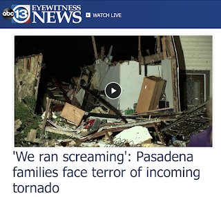
We had a major tornado pass through the densely populated area of southeast and east Houston with other storms east into the Beaumont-Port Arthur-Orange area. Later, tornadoes developed in Louisiana.  As of 11:22pm there has not been a single fatality. That is an amazing scientific accomplishment and all of the meteorologists involved: NWS (especially the Storm Prediction Center), broadcast and commercial meteorology should be praised! There is one story I wish to tell. Take a look at the photo below.  Those railroad hopper cars were blown over by the Houston Tornado. Because the railroad got advance notice of the tornado, the train was stopped when the tornado hit (often, trains are too large a target to get out of the way). You can see that the track is in pristine condition.  If the train had been moving, it would have torn the cars apart, tornado apart the track and, possibly, put cars or contents in the water (foreground). That would have been far more expensive to t...

Path of Damaging Tornado in the Houston Metro

Image
The blue-white line, oriented from southwest to northeast, is the path of a tornado that we know has done damage in the southeast part of the Houston Metro from about 2:25 until about 2:50pm. The extent of the damage and any injuries is unknown at this point. If you click to enlarge, the graphic is considerably better quality.  Addition  (see below) at 3:12pm. Addition: 4:23pm. Remember: the number refers to individual homes and businesses. Nearly 400,000 people  are without power. 

Update on Winter Storm

Image
The winter storm has moved into the Great Plains with snow reported as far east as Oklahoma City. Forecast for additional snow: Radar at 9:28am:

Serious Tornado Risk Later Today and This Evening

Image
The yellow, hatched area has an enhanced  risk of tornadoes this afternoon and tonight. The brown area has a significant risk. Please make sure you have at least two independent ways of receiving tornado warnings and make sure your sheltering area is ready to go.

The Futility of Wind Energy

Image
The timing of a load of wind turbine blades making their way by rail through Wichita this morning, was interesting. The the official NWS wind speed at the time was 3 mph -- which was too light for any electricity to be produced at any of the existing wind farms.  In fact, the weather map of the region at 6am showed winds were too light not just in Wichita (arrow) but over a vast area of Texas, Kansas, and Oklahoma -- states with an exceedingly high number of wind farms. To decode: The large black circle around the inner green circle denotes calm winds. The green circles with the line sticking out of them and a half "barb" at about a 90° angle (I've put an "L" near a few) have winds too light to turn the blades. Where the line with a full barb exists, the winds are okay. As you can see, the vast majority of weather stations in the area have winds too light to generate electricity.  Here's the thing: If someone had taken a magic wand and instantly tripled the ...

5:15pm Update: Winter Storm and Major Tornado Risk Forecasts

Image
National Weather Service Warnings and Advisories Color Codes: Pink = winter storm warning. Turquoise = winter storm watch  Purple = winter weather advisory (lesser condition) Amber = high wind watch Light brown = high wind advisory The forecasts below still look good. Please keep in mind that Arkansas and, especially, Oklahoma do a very poor job with winter storms. I urge  you to leave early and avoid the storm if at all possible.  Forecast Radar: 9am Tuesday Forecast Radar: 5pm Tuesday Forecast Radar: 11:59pm Tuesday Forecast Radar: 9am CST Wednesday Updated Snow Amount Forecasts From now until 6am this Tuesday 6am Tuesday to 6am Wednesday 6am Tuesday to 6am Wednesday Zoom Zoomed forecast for 6pm Monday to 6pm Tuesday. Winds will be moderate with this storm, so there will be a little drifting but nothing major. Note: there is a chance of a snow thunderstorm south of I-40. When once occurs, a quick additional inch or two is possible.  Tornado Risk Unfortunately, for ...

Snow Forecasts: Northeast, Midwest Southern Plains

Image
New England Color Codes: Pink = winter storm warning Purple = winter weather advisory (lesser condition) Southern Great Plains I wish I could tell you I have a lot of confidence in this forecast. There are trustworthy models showing heavier amounts than indicated here. So, check back late this afternoon and I will update this forecast.