
Monday's Tornado Outlook
-- there is an updated forecast above --
This tornado forecast is valid from 2pm Monday until 4am Wednesday. 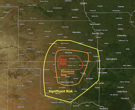 For the purposes of these forecasts I have four risk categories. All of them combine the density of expected tornadoes and their intensities. The highest is the rarely used "extreme risk" (I used it for the first time Friday). This forecast includes areas of high, enhanced and significant risk.

There is a meteorological discussion at the bottom of this posting.
If you didn't Friday, I urge you to insure your friends and families are aware of the threat and prepare your shelter area.
Meteorological Discussion:
I am forecasting rain to fall in the threat area, including Wichita, late tonight and tomorrow morning. This would be similar to Friday's situation. Plus there was early morning rain for the Wichita-Andover Tornado of 1991, the southeast Wichita tornado of 2012 and the east Wichita tornado of September 1992. In each of these cases, the sun came out and temperatures warmed rapidly, destabilizing the atmosphere. If that happens tomorrow, powerful tornadoes will likely result.
A low pressure system will move east near the KS-OK border with a pseudo-warm front providing an excellent environment for supercell thunderstorms.


Comments
Post a Comment