
4:20 pm Tornado and Winter Storm Update
Please make sure you factor this winter storm into
your late-week plans
Overnight Tornadoes Wednesday Night
Let's begin with the overnight tornado and high wind threat Wednesday night and Thursday morning.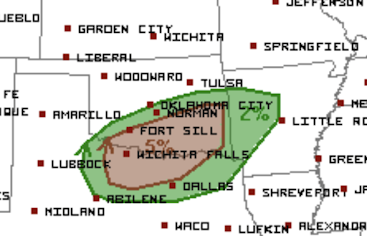
The brown area -- because we are talking an overnight threat -- is an enhanced risk of tornadoes and/or damaging winds (gusts to 80 mph). I would also take the threat area slightly farther east to Ft. Smith and Mena in Arkansas and would advise residents of the Metroplex to make sure they have a way to get overnight storm warnings.
Note: there is a tornado threat over the southern Mississippi Valley and Deep South Thursday that I will cover tomorrow.
Winter Storm Forecast
Here are the forecast snowfall maps.
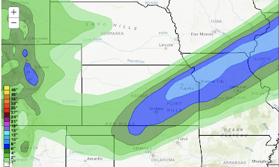
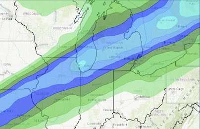
There is a chance of lightning and thunder with the snow, especially in Kansas and southwest Missouri. If snow thunderstorms occur, there will localized areas of much heavier snow (perhaps as 3 extra inches) along with the usual lightning dangers. For this reason, I'm forecasting a bit more snowfall (an inch or two) in Kansas than I otherwise would.
Note: winds will be at least as strong with this winter storm as they were with the storm two weeks ago. With winds gusting to 40 mph. there will be considerable drifting snow. Travel will be hazardous!
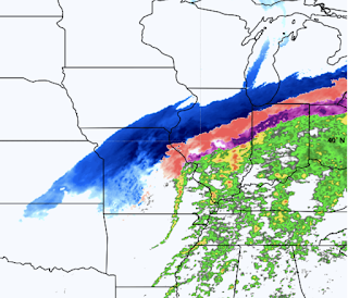
Below is the forecast radar for Noon Thursday.
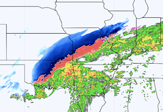
Flood Threat
There is a threat of flooding due to heavy rains in the


Comments
Post a Comment