
20th Anniversary of Lyndon-Lawrence and Yates Center Tornadoes
In June of 2003, terrible wildfires in Mexico sent a pall of smoke into the central United States. It brought visibility down rather significantly across the region. This added to the challenge of warning of the swarms of tornadoes that occurred across the USA from California to Virginia from the 3rd to the 8th. I believe it is still the record for most number of tornadoes during that number of days.
 The tornado had been on the ground for a while but there was no tornado warning. I frantically tried to call the National Weather Service in Topeka but their line was continuously busy. I couldn't get hold of WIBW Radio in Topeka which was in continuous storm coverage. The line was busy at the county sheriff's.
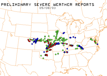
A map of the tornadoes (red) on the eighth is below.

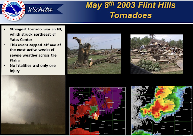
On the 8th, the best known tornado was the Yates Center Tornado. An excellent warning helped prevent fatalities.

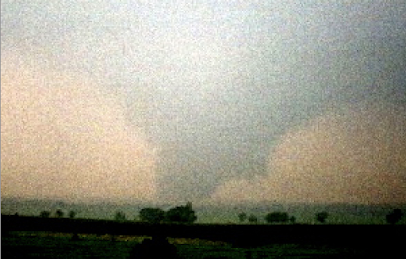
But, the more challenging tornado was the next one farther north. Known as the Lyndon-Lawrence Tornado. I took this photo at close range but the visibility was quite poor because of rain and, especially, the smoke. I watched the tornado envelop a house and leave it heavily damaged (no one was home, thank goodness).

The storm made its way northeast to the edge of Lawrence. It lifted just before reaching the University of Kansas campus. My nephew was sleeping in his fraternity house at the time. He told me he never heard any siren and no one at his fraternity took shelter. I was told by a number of people near the path the warning for this particular tornado left much to be desired.
 I can hardly imagine how much better short term tornado forecasting would be if we still had the profilers combined with today's CAM models. It is a shame the decision was made to eliminate it.
This frustration led me to invent and patent what we called "Storm Hawk Reporter" which allowed GPS-equipped devices to report all types of emergency weather and other critical info (car accidents, etc.) without having to pick up or answer a phone. [FYI: The patent can be licensed by contacting AccuWeather and asking for Michael Root. ]
 |
| Simulation of tornado report sent by Storm Hawk Reporter |
Progress in weather science sometimes occurs because of unique opportunities. This was one of those instances.
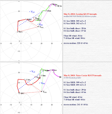
For meteorologists: We've discussed on many occasions the deterioration in tornado warning accuracy during the past decade. Another step backward prior to 2008-2011 (when tornado warning accuracy peaked) was the elimination of the National Weather Service's Wind Profiler Demonstration Network. Below are the hodographs applicable to the Lyndon-Lawrence Tornado and below is Yate Center's.


Comments
Post a Comment