Tornado, Damaging Wind and Large Hail Event in Central Plains
Update: 3:15pm. The forecast below is unchanged. I will tweet updates this evening @usweatherexpert.
-- Original Post --
Damaging Winds and Hail
The hatched area is where wind gusts of 75 mph or stronger are forecasted to occur. The yellow area has a significant risk and the red area has an enhanced risk. Within the red area, plus southwest Nebraska, there is an enhanced risk of large hail -- with some areas receiving hail more than two inches in diameter.
Power failures are likely.
- Make arrangements now for friends and family who would be seriously affected by power failures.
- Charge phones and laptops fully, but take them off chargers the first time you hear thunder.
- Make sure your shelter area is ready to go. If you wish to consider a professional shelter, go here.
- Fill your car with fuel and make sure you have adequate cash.
- Because the storm will be at its worst after dark (see below), have a flashlight or emergency light ready to go.
- Have at least two independent means of receiving storm warnings. Enable the Wireless Emergency Alerts (WEA) on your smartphone and put it next to your bed.
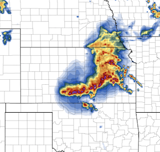
This is the radar forecast for midnight. The derecho will be moving rapidly from northwest to southeast.


Comments
Post a Comment