
First Look at Winter Storm Coming Out of Southwest
For those traveling late this weekend into New Year's Eve, I want to make you aware of the latest in this series of winter storms.
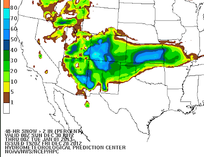 The above map is the probability of 2" or more of snow accumulating between 6pm Saturday evening and 6pm Monday evening (New Year's Eve). The storm will be over the southern Rockies Sunday and will move into the Plains on Monday.
The map below is the probability of 4 inches or more during the same period of time.
 I'm providing this early look because I suggest that you factor this storm into your plans as roads will become hazardous in these areas.

The map below is the probability of 4 inches or more during the same period of time.


Thank you! We have been considering a trip to KC from Wichita ... this will help us make alternate plans. Seems like we might actually be in the bulls eye this time.
ReplyDeleteHoping it also visits SW Missouri as well. Looking at the snow cover map we are surrounded :)
ReplyDelete