
8:30pm Friday: Quick Blizzard and Tornado Threat Update
SEE UPDATE REGARDING BLIZZARD
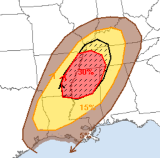
The threat of tornadoes exists after 2am Saturday morning until about 10am Saturday with a more intense threat tomorrow afternoon and evening throughout the yellow area. The hatched area is where violent tornadoes could occur during the afternoon and evening.
 Because the any tornadoes will have forward speeds of 60-70 mph please monitor the weather throughout the day. Use a TV, NOAA Weather Radio or app like AccuWeather's (with location services enabled) to get warnings as quickly as possible. Due to the extremely fast speed, there may be less advance notice than usual.
Little change in the track of the blizzard with amounts increased somewhat. I am confident Interstates 80, 29, and 70 will be closed. Interstate 135 near Salina will probably be closed. The smaller areas where the purples are darker are indications of local amounts of over a foot due to snow thunderstorms. However, the model cannot resolve these exactly, so please keep in mind that these locally heavier amounts may occur anywhere in the purple region.
 Do not try to travel in the blizzard region. Large snow drifts and power failures are likely with this storm. Please prepare tonight, if possible. Do not risk getting caught in this storm.
UPDATE 9:30pm.
 This is forecast radar for 10am Saturday. It looks likely there will be 2-3 hours of blizzard conditions in the rectangle, especially in the northwest half. This includes Guymon, Dalhart and Stratford.
I will update mid-morning tomorrow.
The threat of tornadoes exists after 2am Saturday morning until about 10am Saturday with a more intense threat tomorrow afternoon and evening throughout the yellow area. The hatched area is where violent tornadoes could occur during the afternoon and evening.

Little change in the track of the blizzard with amounts increased somewhat. I am confident Interstates 80, 29, and 70 will be closed. Interstate 135 near Salina will probably be closed. The smaller areas where the purples are darker are indications of local amounts of over a foot due to snow thunderstorms. However, the model cannot resolve these exactly, so please keep in mind that these locally heavier amounts may occur anywhere in the purple region.

UPDATE 9:30pm.

I will update mid-morning tomorrow.


Comments
Post a Comment