
Something for VORTEX-SE to Research
There is a major tornado research program pertaining to tornadoes in the Southeast. I would like to offer a suggestion for some serious research.
I have been viewing weather radar on a virtually daily basis for 48 years. This afternoon, I saw a phenomena I've seen only one other time which was in the late 1970's in Kansas (I don't remember the date): a gigantic (as these things go) rotating mesoscale vortex that was not associated with a supercell thunderstorm that was apparently spawning multi-vortex, violent, tornadoes. I'm bringing this to research meteorologists' attention because I have not seen any coverage of it in the Mississippi media, so far.
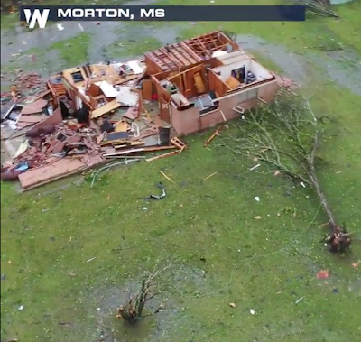
Why is this important? The answer can be easily seen in a video here. A screen capture is below.
Here are some images of the radar data from this unusual storm. The
 "donut" centered just west of Polkville, ten miles in diameter, is unusually large for this type of system. There was a report a few minutes later of a multi-vortex tornado near Polkville.
Here is a wider view with the Doppler wind velocity data on the right. The brownish white tints are
 winds above 100 mph.
It is fairly common for tornadoes to loft debris. This image is commonplace.

But, the image below, which appears to depict rotating debris aloft (it was Tilt 2) is unusual.

This is just a little of what was unusual about this storm. Researchers? Have at it!!
I have been viewing weather radar on a virtually daily basis for 48 years. This afternoon, I saw a phenomena I've seen only one other time which was in the late 1970's in Kansas (I don't remember the date): a gigantic (as these things go) rotating mesoscale vortex that was not associated with a supercell thunderstorm that was apparently spawning multi-vortex, violent, tornadoes. I'm bringing this to research meteorologists' attention because I have not seen any coverage of it in the Mississippi media, so far.
Why is this important? The answer can be easily seen in a video here. A screen capture is below.

It is rare for non-supercells to cause tornadoes of EF-3 intensity which the above image suggests.
Here are some images of the radar data from this unusual storm. The

Here is a wider view with the Doppler wind velocity data on the right. The brownish white tints are

It is fairly common for tornadoes to loft debris. This image is commonplace.

But, the image below, which appears to depict rotating debris aloft (it was Tilt 2) is unusual.

This is just a little of what was unusual about this storm. Researchers? Have at it!!


Comments
Post a Comment