
10pm CDT Hurricane Matthew Update
We have an extremely rare Category 5 hurricane on our hands. Matthew's central pressure is down to 941 mb and sustained winds are 160 mph!
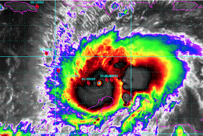
The storm has not begun its northward turn and is still moving southwest. The photo above was taken at 9:15pm CDT. You can see the center is a little south of a straight line between the two forecast points (the red hurricane symbols) on either side of the eye.
I have a concern that being farther south than the projected path, for any length of time, will result in the turn to the north being delayed. That would increase the already serious danger to Jamaica. If you have friends in Jamaica, tell them to prepare for a possibly record hurricane passing near or over the island.

I have a concern that being farther south than the projected path, for any length of time, will result in the turn to the north being delayed. That would increase the already serious danger to Jamaica. If you have friends in Jamaica, tell them to prepare for a possibly record hurricane passing near or over the island.


Comments
Post a Comment