
Charlotte Already Has Quality Wind and Tornado Radar

After dangerous winds killed 37 people and injured 20 others in a Charlotte plane crash in 1994, Charlotte Douglas International Airport was awarded a "terminal doppler radar." "TCLT," as it's known, is in northwest Charlotte and monitors the weather surrounding the airport. The radar is operated by the Federal Aviation Administration and not the National Weather Service.
While helpful for localized weather, a terminal radar is smaller and produces less imagery than its WSR-88D counterpart.
The above is way off. The radar can show storms more than 120 miles away. See below (Charlotte is at far left).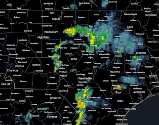
The FAA's Charlotte TDWR (TCLT) routinely produces a new image every 60 seconds, which is better than the NWS radars. The very best the NWS radars can do is 80 second intervals. Most of the time, the NWS radars produce data every 240-300 seconds. And, who cares who operates the radar? It is the data and its quality that is important.
Second, TCLT observes wind shear (the cause of the crash of US Air 1016 in Charlotte in 1994) and tornadoes better than NWS radars.
Example of a Tornado in the Charlotte Area

 |
| Tornado damage at one of AccuWeather's Charlotte area clients |
TDWR Radar Interpretation
Part of the concern, I believe, is that the TDWR can be a bit more challenging to interpret than the NWS's radar. Yet, it is well worth the effort. Below is an example.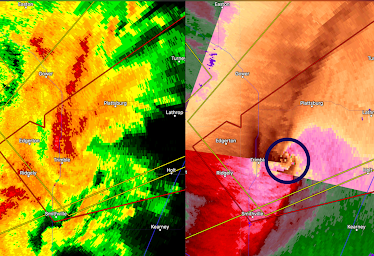 While Kansas City has a NWS radar, this tornado near Trimble, MO did not appear on the NWS's radar. But the Kansas City TDWR did a great job showing its location (circled in the right image) and with its 60-second updates (faster than the NWS radars) allowed precision tracking of the storm.

We had a similar situation in Wichita this past June 17. We have both a NWS and TDWR. A tornado near Derby, KS appeared on the TDWR that did not appear on the NWS radar. The NWS was able to issue a tornado warning as a result.
Again, I have no problem with Charlotte getting another radar. Congress should instruct the NWS to purchase an off-the-shelf S-Band radar and install it in the near future rather than waiting at least a decade. But, the people of Charlotte should not be mislead into believing they do not have protection against tornadoes. The FAA TDWR near the Charlotte Airport is perfectly adequate for that purpose.


Comments
Post a Comment