Posts

Showing posts from January, 2023

8:40pm Ice Storm Update

Image
Right now, the above looks like a faithful depiction of additional freezing rain. The amounts may be a bit high in places, but overall, pretty good.  The NWS's forecasts, before the above model came out, translated into the values (below) on the Sperry-Piltz Ice Storm Index.  A detailed explanation of the Index is here .  The NWS warnings, etc., in the posting below are unchanged. 

Comment on Ice Storm

Image
Deep purple: ice storm warning Pink: winter storm warning (ice) Dark cyan: winter storm watch Purple: winter weather advisory Green: flood warning Gray: dense fog advisory The ice storm warnings are in areas where the NWS believes there is an enhanced chance of power failures. Otherwise, the forecast (two below this) looks good.

What Dallas Drivers are Dealing With

Image
Driving is not recommended -- at all. 

Ice Storm Update: 9:30am Tuesday

Image
Above are the NWS's latest "headlines." Deep purple: ice storm warning Pink: winter storm warning (ice) Dark cyan: winter storm watch Purple: winter weather advisory Green: flood warning Gray: dense fog advisory 9:30am radar. I put highways on so you could see which highways are being affected. Remember, freezing drizzle does not show up well or at all on radar. Current temperature in Dallas is 26°F. Here is the forecast radar for 4pm today.  Here is the forecast radar for 4pm Wednesday.  I'll update again this afternoon. 

Comprehensive Ice Storm Update, 5:30pm Monday

Image
Unfortunately, the south central ice storm is going to be a prolonged event. Keeping in mind that drizzle and freezing drizzle -- which can cause major roadway problems -- are not depicted, here are the forecast radars for the next 55 hours. 4pm Tuesday 4pm Wednesday 11:59pm Wednesday Greens are rain. Yellows are possible thunderstorms. Pinks are freezing rain.  DFW Area Storm Timing Below is an overview of the amount of freezing rain with a closeup of Texas.  If these forecasts are correct, not only will road travel be virtually impossible, there will be power failures. Below is the Sperry-Piltz Ice Accumulation Index which forecasts the extent of power issues. The worst of this is forecast by the NWS to be in the New Braunfels - Austin - Kyle areas. There could be power failures that last days if the forecast is correct. Please prepare accordingly.  Below are the National Weather Service's warnings, et cetera.  Finally, here is the radar (remember, freezing drizzle and drizzle ar

12:30pm Ice Storm Update

Image
Above are the NWS's latest "headlines." Deep purple: ice storm warning Pink: winter storm warning (ice) Dark cyan: winter storm watch Purple: winter weather advisory Green: flood warning Above is the radar at 12:28pm. Salmon color is freezing rain with darker shades = heavier rates of rainfall. Freezing drizzle does not show up. 

Ice Storm Warning!

Image
Color codes: Deep purple: ice storm warning Pink: winter storm warning for ice  Dark cyan: winter storm watch  Purple: winter weather advisory  Green: flood warning There is no difference between an ice storm warning and a winter storm warning for ice. It is an unfortunate quirk of today's National Weather Service. Back in the day, they issued separate "heavy snow warnings" and "ice storm warnings." Here is a NWS map forecasting the amounts of ice. Throughout the area with accumulating ice, travel will be nearly impossible. In the areas in orange and red, there could be power failures.  Please prepare accordingly!

Heads Up: Texas and DFW

Image
National Weather Service "headlines" as of midnight.  Color code: Pink = winter storm warning (ice) Dark cyan = winter storm warning (ice) Green = flood warning  Purple = winter weather advisory (ice). An advisory is a lesser condition than a warning.  However,  The model I trust most in this situation is indicating a heavy accumulation of freezing rain in the DFW Metroplex. The amount of ice will 1) cripple the city in terms of traffic and 2) may cause power failures if I am correct. Therefore, I would make sure I can hold out a few days if the power goes out. 

"You Will Eat Crickets and Like It!!"

Image
While Al Gore and John Kerry fly around on private jets, increasingly the global warming crowd wants you and I to eat crickets. Really. More here . 

Ice Storm Update

Image
While this will not be a massive ice storm, it will cover a large area and will cause major traffic difficulties. The forecast is valid from now until 6pm Wednesday. The worst ice accumulation will be near and west of the Abilene - Sweetwater area and may affect I-20. At this point, I do not expect major areas of power outages but there is always the possibility of isolated power issues.  UPDATE: Here are the National Weather Services storm headlines as of 4:35pm. Color code: Dark cyan:  winter storm watch for the freezing rain. Purple; winter weather advisory (lesser condition). Green and maroon: flood warnings. 

Happy Kansas Day!!

Image
Today is "Kansas Day." Celebrated since 1877, it is the anniversary of when our state was admitted to the Union.  Kathleen and I absolutely love living in Kansas. We have a great lifestyle with a lot cost of living. One issue Kansas has is that none of the interstate highways go through the most scenic areas of the state (with the possible exception of the Kansas Turnpike/I-35 in the Flint Hills).  The above shot was taken in the Gypsum Hills of south central Kansas. It looks like the terrain you see in movies about the "old west."  In any case, happy Kansas Day. And, we hope the Missouri-based Kansas City Chiefs have a great victory against the Bengals!

Sunday Fun

Image
MMMmmmmm, cake. 

Ice Storm and Cold Wave Updates

Image
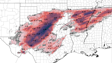
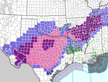
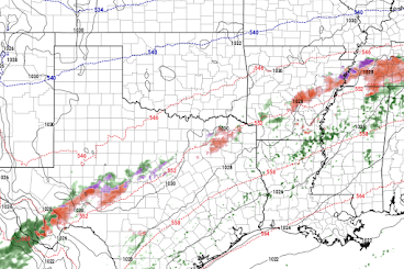
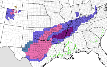
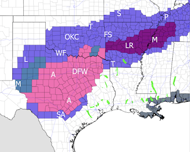
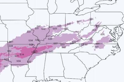
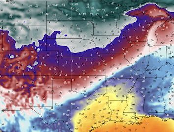
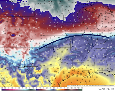
Cold Wave Forecast Above are the forecast temperatures for 6am Sunday. Double-digit below zero temperatures (these are not wind chills) in the northern Great Plains.  If you are one of the 76,000+ going to the Bengals - Chiefs game, the 6pm temperature (top) and wind chill maps are below. I've circled the forecast that is technically for the Lee's Summit (suburb) airport but it is near Arrowhead. The forecast temperature in the first half should be 17°F with a wind chill of  5°F. For Monday, incredible cold in the central United States.  At my house, the predicted low is -10°F! By Tuesday at 6am, the Arctic cold air mass will have reached the Gulf and the below zero low temperatures will have pushed as far east as Indiana.  Ice Storm While I am pretty good at forecasting ice storms without models at about 24-30 hours, beyond that, it is important to use the models. And, there is an extraordinary spread in their forecasts, still. So, what I am doing is taking a pretty reliable b

And, By Wearing a Mask When Alone in Your Car!

Image

Note to Readers

While I see an Arctic cold front moving south, I do not see a major ice storm between now and 6pm Monday.  There is some chance of ice in southern Oklahoma and Texas after that time but it is still highly uncertain. 

Northern Plains Winter Storm

Image
Winter storm is starting from the northern Rockies across the northern Great Plains to Lake Michigan Pink is a winter storm warning. Purple is a winter weather advisory (lesser condition).  The radar shows the storm in the easiest stages.  Tonight, I will begin forecasting the potential winter storm in the southern Great Plains. 

Another Blast of Cold Air Moving In!

Image
As this is being written, another blast of Arctic air is moving south.  Below is the temperature forecast and the location of the cold front at noon tomorrow (Saturday) from the Canadian Global model.  By Tuesday morning, the coldest of the air will bring below zero temperatures to much of the nation. Single digits will extend from Ohio to Texas.  Please prepare accordingly, including caring for your pets.  While on the subject of extreme temperatures, I often talk about how wind energy fails when needed the most. Below is a closeup of forecast temperatures Tuesday morning for Kansas and southern Nebraska. Note Lincoln and Omaha forecast to be -13°F (circled).  The wind forecast is below with Lincoln and Omaha circled. Their forecast wind speed? Just 3 mph! Numerals are wind speed. Arrows are wind direction. Since wind turbines do not turn with wind speeds of less than 6 mph, virtually the entire area of below zero temperatures will have winds too light to generate electricity from win

Elderly Woman Stands in Middle of Dessert Talking to Herself

Image
I wonder how much energy was expended in hauling furniture to the middle of nowhere for someone named Jennifer Granholm to speak to no one? I'm also curious, from where did the power come to run the microphone, speakers and teleprompters? 

Engineering Analysis of Low Carbon Energy Alternatives

Increasingly, engineers -- the people actually understand how the grid works -- are speaking out against the mindless installation of wind and solar with no real plan as to how the new grid is going to work.  This is an excellent piece that I highly recommend. The bottom line is that nuclear is incompatible to wind+solar: that if you install nuclear, there is no reason for those poor technologies. As we have previously discussed, wind (especially) and solar advocates hate nuclear for that reason -- with it, the global warming problem is solved (no more issue for fundraising) and their ideas for a quaint semi-1890's American energy dissipate.  However,  as the piece points out, this only works if the nuclear is reasonably priced. The laughably expensive plants currently under construction are so expensive because the industry seems to be in love with one-off designs. There were plans to create standardized designs that would be much less expensive. Those need to be dusted off and u

Looking for a Keynote Speaker?

Image
Live Presentation in Dallas If so, I'd like you to consider one of our live presentations. Original and informative, we've engaged audiences from Honolulu to New York City to Miami. Whether it is climate change, tornado safety, weather and the economy, or other topics, your audience will thank you.  For more information, please contact Ms. Mindy East at Barron Ridge Speaker's Agency . 

Drought Situation Across the United States

Image
Above is the Palmer Drought Index as of January 20th, the latest available. The drought has eased considerably over California and throughout the West with a few spots of wetter than average conditions. Over the next week, light to moderate precipitation is forecasted to occur over the state, so things should continue to improve.  By far the worst drought now is over Iowa, Nebraska and Kansas. Unfortunately, this latest storm largely missed this areas.  It looks like there will be another storm as well as a cold wave at the end of the month. I'll have more on that either this afternoon or tomorrow. 

Winter Storm Update

Image
Pinks are winter storm warnings. Purples are winter weather advisories (lesser condition). Browns are strong wind areas.  The tornado risk in Florida is winding down. There is a second area of significant tornado risk (brown). in the Carolinas.