Posts

Showing posts from June, 2023

Today's Tornado Risk

Image
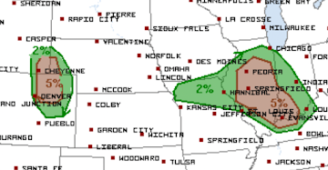
With everyone traveling today, it is important to note that the brown ('significant risk') area is along I-70 and U.S. 40 in western Kansas and eastern Colorado. 

The Huge Number of Drowning Deaths in Rip Currents

Image
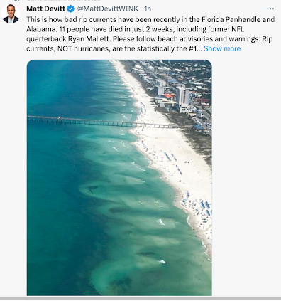
With the holiday weekend at hand, the caution regarding rip currents is timely. I had no idea so many were drowning in them. Vital safety information is here .  They can be easily seen from above, as in the photo, but are difficult to see at beach level. So, I urge you to follow the flags and the advisories online and on the radio.

Another Quizzical Tornado Warning

Image
While this tornado caused damage in central Illinois early this afternoon, hopefully no one has been injured. But, I simply don't understand what transpired and I'm hoping some of my helpful readers can fill me in. The possibility that tornadoes could occur in central Illinois was forecasted by the NWS Storm Prediction Center at ~11:45am (brown, below). Given the fact that a derecho was approaching the area at 70 mph, it was essential Lincoln - Central Illinois radar be switched to the 80-second "tornado" mode. At 12:06pm (velocity time, upper right of the frame), there was very weak rotation just west of Berlin, IL.  Had it been me, I would not  have issued a tornado warning at this time. The rotation was too weak. I have highlighted the town of Loami, which becomes important in the next frame.  Because of the 3.5 minute interval between frames, the next data indicates  a full-fledged tornado is doing damage! Any hope of advance warning was lost because the radar was

Wind Energy is Falling Apart -- Literally

Image
The full story is here .

Updated 12:10pm: Midwest Derecho In Progress

Image
Significant Risk of Tornadoes in Brown Damaging Wind Forecast The hatched area is where wind gusts of 75 mph or stronger are forecasted to occur.  The purple is the highest probability. Here is the radar at 12:04pm. There is a second line of thunderstorms with damaging winds moving into northern Tennessee. It will move across Nashville soon. We are approaching 100,000 people without power and that number will grow. 

National Weather Service Tornado Warnings: What Is the Fix?

We have discussed the fatal tornadoes of the past seven weeks ( here , here and here ) in addition to the numerous other examples from earlier this year.  What is the solution? I'm not sure.  One very quick fix would be for the head of the National Weather Service (NWS) to issue an immediate order for the field offices to stop the nonsense as regards radar operations when tornadoes are forecast: the radars immediately go on 80-second update intervals until things are all-clear throughout their county warning area.  Running the radar at seven-minute intervals during a tornado forecast is a formula for utter disaster, especially at night.  The rest isn't as clear. Undoubtedly, there is a training issue. A quarter-century ago, the NWS ran a 4-week radar and storm warning training course in Norman, OK and all of its meteorologists were required to attend. That no longer exists. With the retirement of my generation of meteorologists, all of that expertise has walked out of the doo

Matador: Another Fatal Tornado Without Adequate Warning

Image
After initially believing the warning for last week's Matador, Texas, Tornado was adequate, my opinion has -- strongly -- changed. Investigative Report © 2023 Mike Smith Enterprises, LLC After receiving suggestions from chasers in the field and others, I've reviewed the National Weather Service (NWS) "chat" from the Lubbock and Amarillo field offices. Those concerned individuals are correct. This incident is just inexplicable.   It was Lubbock that had the responsibility to provide advance warning for Motley County on June 21, 2023. Keep in mind the National Weather Service's stated goal is 13 minutes' advance warning for a tornado. From 2000 to 2010, the NWS routinely achieved that goal. It has regressed considerably since.  The first issue was -- yet again -- the radar was being improperly operated during a tornado watch. Instead of operating the radar at 80 second data collection intervals, the radar was set to collect data at 360 second intervals -- six mi

Derecho With 100 mph Winds and 3" Hail...

Image
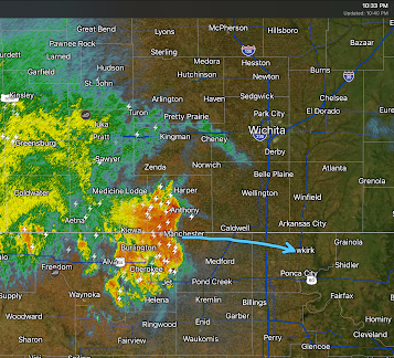
Update   10:40pm, the cluster of thunderstorms which comprise the derecho as constricted in north-south extent with the resulting strongest winds near the KS-OK border. See below: Peak winds near the arrow will be around 70 mph with less strong gusts as you move away from it in the north or south directions.  I do not  think Tulsa will receive damaging winds overnight.  ---------------------- ...in addition, a "couple of tornadoes" are forecast to occur. This severe thunderstorm watch is in effect until 2am CDT.  This is a highly dangerous situation. If friends or family live in a mobile home, call them and suggest they spend the night.  Power failures are likely . I urge you to prepare.  Trees will likely fall, If you have a chain saw fill it with fuel. Fill your car with fuel (pumps and chargers don't work) in advance of losing power.  Get a few extra dollars at the ATM. Cash is valuable when card-readers don't work. Make sure the children are aware. Pick any ripe t

High Risk of Damaging Winds With Tonight's Derecho!

Image
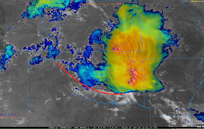
The meteorological question is: will the thunderstorms in southern Kansas this morning (now in eastern Kansas and Oklahoma as seen on the satellite image below (12:45pm). The red line is the collision between the extremely hot and unstable air to the south and the rain-cooled air to the north. It is going to have to change direction in Oklahoma and move back to the north for this system to -- unfortunately -- reach its whole potential. There is a low pressure system in the upper atmosphere that was approaching the KS-CO border and was expected to arrive around 4pm CDT. FORECASTS Because of the presence of the rain-cooled air boundary, there is a slight risk of a tornado in the area outlined in red.  The area in purple has a high risk  of winds of 60 mph or stronger. A "derecho" (an area of damaging winds that extends for more than 100 miles): Here is the color code: Purple is a high risk of winds of 60 mph or stronger. In addition to the highest risk of damaging winds, giant

Derecho Forecast Update: KS, OK, and Ozarks

Image
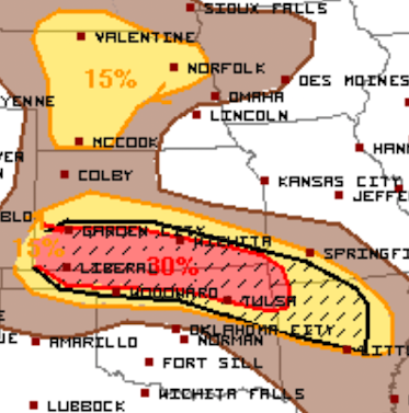
This forecast has been updated as of 2:15pm. Scroll up. ______________________________________ The yellow area has a significant risk of 60-74 mph winds. The red area has an enhanced  risk of those winds and -- where you see the hatching -- gusts may exceed 75 mph. The models that did an outstanding job on the derecho of 17th, say that a few spots may have gusts of 90 mph. If the forecast is correct, there will be extensive power failures and tree damage.  The initial thunderstorms will form in southeast Colorado around 3-4pm. They will congeal near the KS-CO border and then move rapidly east. They should slowly weaken when they reach the Ozarks by the end of the forecast period which is 7am CDT Wednesday.  Giant hail is possible, especially west of I-35, with smaller hail to the east.  Now   is the time to prepare!  Safety recommendations are below: Call friends and relatives to make sure they are aware of the threat, especially if they live in a mobile home.  Make sure you have at le

"You Can't Fix Stupid"

Image
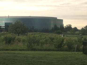
A friend of mine says that occasionally and, in this case, I agree with her. Taken a few minutes ago during a severe thunderstorm warning that included the golf course. Two of the three golf carts are visible and they are headed toward the first green. Please allow me to emphasize that lighting (with thunder) was occurring and a severe thunderstorm warning for 70 mph winds was in effect.  There's only so much meteorologists can do!

Meteorologist Humor

Image
Via Twitter Tornadoes just cannot get any privacy these days!

Derecho Risk Update

Image
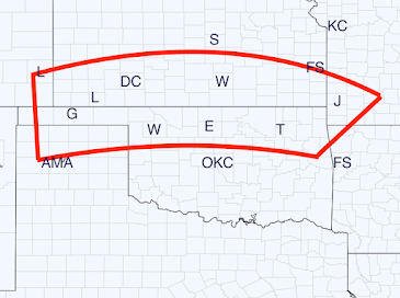
I've looked over the models this evening and the area enclosed in red is where I am projecting the potential derecho's path starting around 5pm Tuesday and continuing to 2am Wednesday in the Ozarks of Missouri and Arkansas. It is highly uncertain whether the derecho will continue southeast from there. There is some risk of a tornado or two to the west of I-35 but that is also highly uncertain at this point.  There is a possibility that winds may gust to 90 mph in places. If so, there will be extensive power outages and felled trees.  Now   is the time to prepare . Safety recommendations are below: Call friends and relatives to make sure they are aware of the threat, especially if they live in a mobile home.  Make sure you have at least three ways of receiving storm warnings. Since the threat along and east of Interstate 35 will be at night, StormWarn is a great way to receive information. It worked great at 11:30 last Saturday evening when we had a tornado warning that include

Damaging Winds on the East Coast This Afternoon; In the Central Great Plains Tuesday

Image
The Rest of the Day The NWS says there is a high chance of damaging winds and a smaller chance of large hail along the East Coast the rest of this afternoon and this evening.  Please monitor local sources of weather information. Fallen trees are likely along with widespread power outages, if their forecast is correct. Tuesday Afternoon and Night There is an enhanced  risk of a derecho in the central Great Plains. The hatching means that winds may exceed 75 mph which means widespread power outages. Wind-driven hail is likely along and west of I-35. Now   is the time to prepare . Safety recommendations are below: Call friends and relatives to make sure they are aware of the threat, especially if they live in a mobile home.  Make sure you have at least three ways of receiving storm warnings.  If you live in a mobile home, you may wish to move spend time with a friend or relative when a tornado or severe thunderstorm watch is issued.  Ask yourself what you would need if you were without el

Beyond Absurd

Image
Because NYC pizza ovens are causing global warming. 🙄 This stopped being about global warming years ago. This is solely about control. The more we give in, the more authoritarianism we are going to get. 

3:50pm Tornado Risk Update

Image
There is one tornado watch already in effect. In addition, I believe tornadoes are likely in the area outlined in red (below).  Now it is Ohio that needs to monitor trusted local sources of weather information.  Follow me on Twitter @usweatherexpert . I'll be posting addition updates there. 

Midwest Tornado Risk!

Image
There is an  enhanced  risk of strong tornadoes in the Midwest today --- depicted by the hatched yellow. The brown area has a significant risk.  It has been quite a while since a tornado risk this high presented itself.  Now   is the time to prepare .  Call friends and relatives to make sure they are aware of the threat, especially if they live in a mobile home.  Make sure you have at least three independent ways of receiving storm warnings.  These include a weather radio, an app,  StormWarn  (I can personally vouch that is is excellent), and a nearby siren you are certain you can hear indoors.  If you live in a mobile home, you may wish to move spend time with a friend or relative when a tornado or severe thunderstorm watch is issued.  Check your tornado shelter. Make sure it has a couple of bottles of water and, if appropriate, diapers. Any essential foods or medicines should be taken into the shelter with you along with any family heirlooms. Have all of your devices charged but  dis

Sunday Fun: Biography of the Coolest Man in America

Image
Highly, highly recommended. It is very entertaining as well as interesting.

President Biden Actually Proposed This

Image
I listened to the tape: President Biden indeed proposed this railroad.  As the construction progresses through the jungles of south Asia, I have just the work song!

Tornado Watch for Iowa

Image
In addition to tornadoes, 2.5" diameter hail and 70 mph thunderstorm-generated winds are forecasted to occur. Please monitor trusted local sources of weather information.  I am not able to live Tweet the storms this afternoon and evening. 

Today's Tornado Risk, Updated

Image
There are two areas with a significant risk of tornadoes (brown). Also, giant hail is forecast to fall in the Iowa tornado risk area.

American Cannot Continue With Two Systems of Justice!

Image
Hunter Biden's sweetheart deal from the Department of Justice should be rejected by the federal judge in the case. 

High Plains Tornado and Severe Thunderstorm Risk

Image
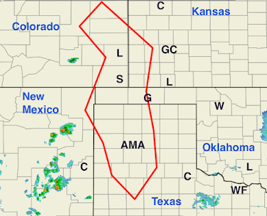
The radar echoes in Colorado and New Mexico will move east and multiply. They will become severe (large hail and damaging winds) with a chance of producing tornadoes when they arrive in the red outlined area.  This evening, the risk of tornadoes will increase in the High Plains as well as the risk of damaging winds.  Tornadoes have already occurred in Wyoming. I'm covering that and will cover these storms on Twitter @usweatherexpert . UPDATE: 2:26PM MDT. As soon as I mention the tornadoes that have occurred in Wyoming, NWS SPC issues a tornado warning for the northern area. Please monitor local weather information in this region of Montana, Wyoming and Nebraska. 

Today's Tornado Risk

Image
The area in brown has a significant chance of tornadoes this afternoon and evening. There is also the potential for a large damaging wind event in the northern Great Plains.  Please monitor local weather conditions throughout this region.