Posts

Showing posts from April, 2024

Tuesday and Wednesday's Tornado Risk

Image
The brown area has a significant risk of tornadoes Tuesday afternoon and night.  Here is a very preliminary  forecast for Wednesday. The hatched area is where the SPC believes strong tornadoes and giant hail is possible.  There is a unique issue raised by these forecasts. To where are people with damaged homes to go if a tornado warning is issued? Fortunately, we now have maps and lists of all known public tornado shelters in the USA? You can access that information here . If you need a shelter apart from you home, now is the time to do the research and make your plans!   

Welcome New Readers!!

Image
First of all, I would like to thank the more than 500,000  first-time blog readers and 200+ new Twitter/X followers the past three days. We were very glad to have you join our severe weather coverage and hope you will visit often.  The primary topic of this blog is extreme weather and its effects on people, society and business. On slower weather days, we discuss climate change and other topics of interest. While we discuss the workings of government, we do not  discuss politics (defined as the "art and science of winning elections and influencing public opinion").  As an FYI, I am a weather science entrepreneur who created the award-winning WeatherData, Inc and sold it to AccuWeather Enterprise Solutions where I was Sr Vice President. I retired in 2018. I am also a retired Fellow of the American Meteorological Society. I have written a popular book about the storm warning system and am a semi-professional photographer. Background Information Here's some background infor

Meteorologists Save Lives!

Image
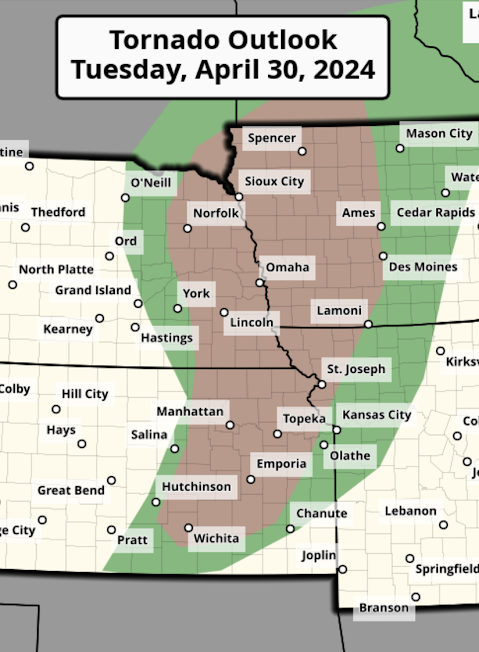
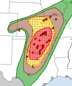
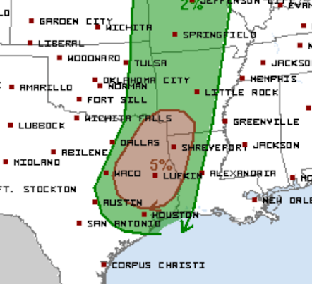
The red dots are tornado locations plotted on top of Saturday's tornado forecast . Fifty years ago this month (April 3 and 4, specifically), a rash of 147 tornadoes struck the United States east of the Mississippi River. Inconsistent radar coverage, slow communications, and lack of meteorological knowledge pertaining to tornado formation meant the tornado warnings were often late or of poor quality. As a result, 335 people lost their lives. Damage, in today’s dollars, reached $5.3 billion.    Friday and Saturday, 152 (preliminary number) tornadoes occurred. The death toll? Just four. While those deaths are unspeakable tragedies for the friends and families of the deceased, the fact is that the modern tornado warning system saved more than 300 lives.    Fifty years ago, the University of Oklahoma storm chase program (along with subsequent field research programs), which has yielded so much practical knowledge about the development tornadoes, was just two years old. The high-speed we

A New Week

Image
We had amazing formations of towering cumulus clouds at sunset yesterday evening. Let's hope we have a much less stormy week than the week just past.  I will post comments about the recent tornado outbreaks later today.

Note to Readers....

Monday, I'll have an essay up regarding the Friday and Saturday's tornadoes that I believe you will find interesting. 

Tornado Watch and Warnings in Texas

Image
As of 2:59p, the dark red is a tornado watch and the bright read polygons are tornado warnings south and east of Waco. Please take safety measures. You will find additional coverage usweatherexpert  on Twitter. 

Big Announcement! U.S. Figure Skating Championship

Image
The details are here . Come and visit!

Weekly Rainfall and Forecast

Image
Above is the rainfall for the past seven days. Near the Missouri-Kansas border, more than 14 inches fell. Unfortunately, most of the rain missed the southern High Plains where it is badly needed. Little rain is forecast for the Southern High Plains or Southwest this week. Hey rains are likely in the South. 

Today's Tornado Risk

Image
After the tornado siege of the past 48 hours, things will be a bit calmer today -- but tornadoes are still in the forecast.  The brown area has a significant risk of tornadoes. Please keep an eye on the weather today and this evening. 

Sunday Fun: Dad Takes Daughter on a Roller Coaster Ride

This is one of the sweetest things I have ever seen! Click here . 

[1:10am Update] Tornado Forecast for Rest of the Night

Image
Thank you  for coming to read my tornado coverage from Saturday and Saturday night. As there were about 100,000 brand new readers, please allow me to introduce myself. I the retired Sr. VP of AccuWeather Enterprise Solutions and retired Fellow of the American Meteorological Society. Specialized for 50 years in extreme weather forecasts and warnings. I invite you to bookmark this site:   https://www.mikesmithenterprisesblog.com/    Timely forecasts of tornadoes, floods, blizzards and hurricanes are provided. On slower weather days we talk about global warming, science and issues of interest to society. On Sundays, we usually lighten things a bit. For real-time storm warning bulletins, you can follow me here:   @usweatherexpert .  Thanks again  for reading! ---Last night's Coverage --- After 16 straight hours, I must call it a night. All of the information below is current as of 1:10am. Thank you for reading and goodnight.  As of 12:35am, much of south central Oklahoma has no electr

First Tornado Watch of the Day Issued

Image
Unfortunately, the forecast is working out. A tornado watch is already in effect in Oklahoma and Texas.  This watch is in effect until 1pm.  Thunderstorms are developing in the southeast Texas Panhandle. They will move northeast and strengthen. Please keep a close eye on the weather in these areas.  I'll have comprehensive forecast up in 60-90 minutes.

Comments on Today's and Tomorrow's Storms

Image
Today was an incredible day, unfortunately.  So far, 94  tornadoes have been reported and it appears that many of them were strong and, perhaps, even violent.  The metropolitan areas of Omaha, Des Moines and Lincoln were all hit. Several rural towns were flattened. Yet, as of this moment (9:46pm), there have been no serious injuries.  That is to the tremendous credit of the National Weather Service, broadcast meteorologists, storm chasers and private sector meteorologists. I spent more than 12 hours today forecasting and warning of the storms. Trying to warn of every storm in time, without false alarms (to the greatest extent possible) is taxing and exhausting. Unfortunately, there is the possibility that we may have to go through another tornado outbreak tomorrow. My forecast is here . I do not know whether will be storm chasing (from which I will post updates to Twitter) or will do another day from home.  It is vital that everyone in these areas pays attention to the weather if they

Tornado Paths

Image
These are radar-derived low-level rotation maps as of 7pm.  Eastern Nebraska, including the Lincoln-West Omaha + Omaha/Eppley Field Storm. Likely long-track tornado from SE Kansas crossing into western Missouri. Below are individual storm reports:

Tornado Forecast for Saturday, April 27

Image
I believe Saturday presents a major tornado risk to residents of southeast Kansas and much of the east half of Oklahoma.  The color code: The area in red has ( on my 4-point scale of significant/enhanced/high/extreme) a high  risk of strong tornadoes. Strong is defined as EF-2 or stronger. Yellow, hatched has an enhanced  risk of tornadoes. The brown area has a significant risk of tornadoes.  Below are enlargements of the enhanced and high risk areas: Tornadoes could occur any time Saturday and/or Saturday night. I recommend you monitor the weather throughout the day in these areas.  The entire enhanced and high risk areas are likely to receive giant hail (defined as 2" or larger) with any strong thunderstorms, tornado-producing or otherwise. If you live in a mobile home or a home, in the strongest way possible,  please locate -- today -- a nearby community shelter. You can find them here .  If you shelter at home, please remember: Have a least three independent ways of receiving

6 pm - Current Tornado Forecasts

Image
Tornado Watch until 11pm. Tornado Watch until 9pm. This watch has been cancelled for Kansas.    Tornado Watch until 9pm.   More tornado watches are below, please scroll down.  Tornado Watch until 7pm. Updated Forecast  The yellow, hatched area has an enhanced risk of tornadoes. The brown area has a significant risk. Kansas City has been removed from the enhanced risk of tornadoes but remains in the significant risk.  Below are close-ups of the tornado risk areas. Please keep up on the weather in these areas, especially if you live in the hatched area. You can follow my real-time updates on Twitter @usweatherexpert.  You may wish to recommend this blog and my Twitter handle to friends and relatives in the affected areas.  If you, for example, live in the mobile home and need a community shelter, a list and map is here .  I am going to make a separate posting for tomorrow's tornado forecast. It should be up early this afternoon. 

Note to Readers...

Image
I'm working on the latest forecast for today and Saturday's tornado and severe thunderstorm risks.  Severe thunderstorms continue in southeast Oklahoma. 

Overnight Tornado and Severe Thunderstorm Risk - 9:45pm

Image
As predicted (see below), a cluster of thunderstorms will develop over this area and will move northeast during the night. This watch is in effect until 4am Saturday My detailed forecast is below.  Through Tonight There is an enhanced  risk of strong tornadoes in western Kansas (details below) after 2pm and the risk will last until around 1am. There is an enhanced risk of tornadoes in northwest Texas and southern Oklahoma after 9pm and continuing overnight. They are not likely to be strong (of course, all tornadoes are dangerous). The brown area has a significant risk of tornadoes. I have expanded on the Kansas forecast (2pm until 1am) below: The hatched area has an enhanced risk of strong tornadoes. The red area has a high risk of a strong tornado. Apologies for my lack of artistic ability. I have extended the enhanced tornado area a bit farther to the east and, especially, northeast near the predicted location of the warm front.  I will have updates this afternoon and tonight on Twit

Tornado Forecast for Friday and Saturday

Image
Friday and Friday Night This is the forecast for all day Friday as until about 2am Saturday. Here is the color code: Yellow, hatched has an enhanced  risk of strong tornadoes.  ?  = some possibility of having to upgrade the risk in the 4-state area. The upper air indications plus a couple of the models indicate that we may have to elevate the risk in that area. The entire brown area has a significant risk of tornadoes.  Saturday and Saturday Night Here is my forecast for Saturday.  The red area has (on my 4-point scale) a high risk of tornadoes. The orange area has an enhanced risk and the yellow area has a significant risk. While it doesn't seem like it, 48-hours is a long time in tornado forecasting, so this may have to be modified. However, if you live in the areas outlined, please check back with this blog for later forecasts and with local weather information on Saturday. I do frequent updates on Twitter @usweatherexpert. Please follow me for additional updates. Thank you. 

3 Days of Big Storms [Updated]

Image
This is a situation where people in the areas of the forecasts should closely monitor the weather. Please make sure friends and relatives are aware of the risks -- especially on Saturday. More below on Saturday's storms.   Thursday and Thursday Night The brown area has a significant risk. The area of yellow hatching has an enhanced risk of strong tornadoes. The red area has an even higher risk. Thunderstorms will likely form around mid-afternoon with the higher tornado threat from 6 to 10pm.  Friday and Friday Night The yellow area has a significant risk of tornadoes and/or severe thunderstorms. There is an enhanced  risk of tornadoes in the red area. The hatching is where giant hail (2' or large is forecast to fall). Especially if you live in the red area, keep an eye on the weather Friday. Saturday and Saturday Night I have a bad feeling about Saturday. The first map is SPC's entire forecast area. The yellow is where there is a significant chance of tornadoes/large hail/