Welcome New Readers!!
First of all, I would like to thank the more than 500,000 first-time blog readers and 200+ new Twitter/X followers the past three days. We were very glad to have you join our severe weather coverage and hope you will visit often.
The primary topic of this blog is extreme weather and its effects on people, society and business. On slower weather days, we discuss climate change and other topics of interest. While we discuss the workings of government, we do not discuss politics (defined as the "art and science of winning elections and influencing public opinion").
As an FYI, I am a weather science entrepreneur who created the award-winning WeatherData, Inc and sold it to AccuWeather Enterprise Solutions where I was Sr Vice President. I retired in 2018. I am also a retired Fellow of the American Meteorological Society. I have written a popular book about the storm warning system and am a semi-professional photographer.
Background Information
Here's some background information regarding our weather forecasts and storm warnings.
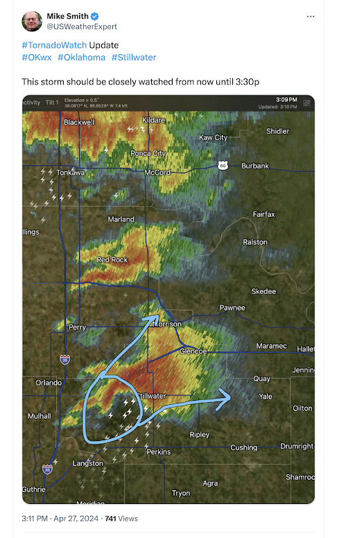
We provide independent coverage of major weather events of all types. What do I mean by "independent"? While meteorologists cannot provide forecasts and storm warnings without the meteorological infrastructure provided by the National Weather Service, our forecasts and warnings -- when I believe necessary -- are independent of theirs. Here's an example from Saturday:
This cautionary statement regarding tornado potential was posted at 3:11pm. It appeared that rotation was developing in the storm in an atmosphere favorable for tornadoes. The was no tornado warning from the NWS at that time. The NWS issued their tornado warning at 3:22pm.
You'll also find our forecast was, correctly, for a high risk of tornadoes for areas of eastern Nebraska and western Iowa for Friday and for southeast Kansas and eastern Oklahoma on Saturday. This differed from other forecasts at those times. The Saturday forecast is below. We added the red ("high" risk) to SPC's forecast (yellow).
Below are the probabilities based on the actual tornado locations. |
| Victor Gensini |
I will post on the topic of climate change and tornadoes later in the week, after the tornado potential for tomorrow and Wednesday has passed.


Comments
Post a Comment