Posts

Showing posts from July, 2023

Flash Flood Risk Tonight

Image
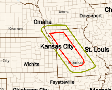
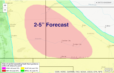
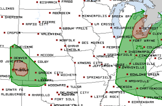
Flash flood conditions are in progress in Colorado to the south of Denver. They will worsen for at least the next three hours (10:30pm MDT). Please keep up with local weather information.  After 11pm, I expect thunderstorms with heavy rain to develop in the red area of western Missouri below. There is a chance of heavy rains in the green area. It would not surprise me for 6 to 8 inches of rain to fall in a spot or two. If this is correct, it will cause significant flash flooding. If you live in a low or flood-prone area, please take your smartphone to bed.  Update: Here is the rainfall that fell up to 8am.  And, it is still raining in Missouri as of 9:14am. 

Why We Urge Sheltering on the Lowest Floor

Image
Due to friction with the ground, wind speeds are lowest near the ground and increase with height. In tornadoes, the basement is best. If you don't have a basement, go to a bath or closet in the middle of the home on the lowest floor. In hurricanes, a basement is not as certain due to the possibility of flooding. It is probably better to shelter in the middle of the house and definitely away from windows. 

Spectacular Lightning Display

Image
This is one of the most spectacular lightning time-lapses I have seen in a long time. Please enjoy!

Sunday Fun: The Mesocyclone

Image
Pecos Hank has produced another of his inimitable videos. This time, the topic is the mesocyclone that drives supercell thunderstorms. 

This Is Not Meteorological Progress

Image
I'm so old I remember that it was supposed to be hot in the summer. 

Area of Extreme Winds Possible

Image
The hatched area is where wind gusts of 75 mph are forecast to occur the rest of the evening.  8:10pm, NWS is forecasting winds in excess of 80 mph in the area outlined below. 

7:15pm Update

Image
Scattered severe thunderstorms and, in northeast Iowa, a few tornadoes dave developed. The weather system moving southeast in Wisconsin has the best chance of congealing into a major wind system. 

More Power Outage Problems Likely

Image
We have another day with the possibility of a major windstorm.  The yellow area has a significant risk of thunderstorm-generated wind gusts of 60 mph winds or stronger. The red area has an enhanced  risk. Below is a map of where people are still without power. The numbers represent "customers" (homes and businesses) without power. That represents about 300,000 people in the Midwest.  Another storm will only worsen the situation. While on the subject of the Midwest storms. the yellow area has a significant risk of 1" hail or larger. Where you see the hatching, hail 2" or larger is forecast to fall. I will update again this late this afternoon.

A History Lesson

Image
A lot of historical revisionism has been floating around social media since Friday's release of Oppenheimer  -- much of it claiming (paraphrasing), "invading Japan would have been no big deal." I believe this pretty much settles the issue. 

The First Tornado Detection By Doppler Radar

Image
Actual Image of El Dorado Tornado KAKE-TV in Wichita has produced an outstanding  documentary on the first-ever use of Doppler radar to detect a tornado, which was in Wichita in 1958. That tornado struck the City of El Dorado, Kansas. It was an F-4 intensity tornado (would be rated EF-5 today) that killed 13.   After World War II, Wichita received the first-ever weather radar from the Weather Bureau. Then, in 1958 and '59, we and Wichita Falls, Texas, had experimental Dopplers (image below).  The radar in Wichita measured a wind of 206 mph in the El Dorado Tornado. Unfortunately, it would be 34 years before the first operational Doppler radar would be deployed for the detection of tornadoes and other storms.  While I had no involvement in the production of KAKE's excellent documentary, there are some personal notes I would like to add. First, the people of El Dorado have, over the years, been extremely kind to me. I was so honored to speak at the dedication of the tornado memo

Great Lakes Tornado Risk

Image
The area in brown has a significant risk ofd tornadoes. Please monitor trusted local weather conditions throughout the day. 

Absolutely Right

Image

Tornado Risk Wednesday: Great Lakes Region

Image
This is the Wednesday and Wednesday night tornado forecast from @nadocast whose forecast, in this situation, I believe is most correct. Using my scale: Red = high risk Yellow = enhanced risk Brown = significant risk Please do not take the location of the red dot too literally. Given that it is the day before, the entire forecast may shift a bit.  My intention is to give the region a "heads up" and to suggest that residents of the region monitor trusted local sources of weather information tomorrow. 

Global Warming: How True!

Image
And, yet, this huge hypocrisy  -- which infects so much of climate science -- is unrecognized by the insiders.  So, I was shocked yesterday when the Washington Post,  one of the leading conveyors of climate hype, ran this article: Of course, I would say that "throwing money at counterproductive solutions" is not much of a policy. Regardless, the article, which is here , seems pretty mild and obvious to me. I surmise that is true of most readers. But, as the author notes, "angry climate activists" will reject common sense. He ends the article: This inevitably means talking about climate change more as a problem to be managed than as a crisis that requires a total restructuring of the economy. The fact that many climate activists angrily reject such language suggests sustainable progress in fighting climate change will remain elusive. "A problem to be managed." Where have our readers heard that before?  But, before you become optimistic that, at last, maybe

Great Stock Photography...

Image
...with more added almost every week . With autumn coming up: And, if you don't see what you need at my Adobe collection (above), there are more business-focused photos at Shutterstock . Please check them out. 

Shame on Climate 'Science'...

Image
Climate 'science,' where hype overcomes facts. This is what drives me crazy about climate 'science' and climate scientists. They should be condemning this unscientific nonsense in the strongest possible terms. Instead, silence. Here is the issue as reported by Bjorn Lomborg and Jo Nova , the allegedly scientific journal Lancet  attempted to visually overstate the number of deaths due to heat when we know -- and has been reported on this blog innumerable times -- cold kills far more. So, what did they do? They distorted the graph!  Below is the base axis: On the left is the legend for deaths due to cold. On the right side of zero is the axis for heat deaths. They are not close to being equal! The graph on the left is how it was presented in Lancet, which makes it look like heat deaths number far more than they actually do. On the right is Bjorn Lomborg's graph of the same numbers of deaths with the same axis. It becomes easy to see that cold kills ten times more than

Sunday Fun: And, I'll Be Behind Them in the Drive-Through!

Image
But, will the McMarriage package include Diet Cokes? Can you imagine the size of the cardboard carrier?

NO, The World Is Not Burning Up

Image
Since you've heard this from me many times, I decided to link to two other experts: Dr. Cliff Mass  has a PhD in meteorology and is a professor of meteorology at the University of Washington. Cliff walks his readers through the meteorology, here .  Dr. Roger Pielke, Jr.  is a policy expert in Colorado.  He works on the meteorology with his father, the distinguished Dr. Roger Pielke, Sr. His piece on the incredible hype surrounding heat is here .  Addition:  July 23. Dr. Ryan Maue has plotted (above) the daily high temperatures from 2014 to 2022 in black with 2023 in red. As you can see, there is nothing especially unusual about this year.  It is all hype. 

Flooding Likely

Image
Widespread 2-5 inch rains are expected late this evening and into the pre-dawn hours in the red area. Areas of flash flooding are likely.  There is also a good chance of damaging winds later this evening and late tonight. Winds may gust over 75 mph in the hatched area. At 6:50pm, the NWS SPC says this is the corridor for the strongest winds. Please keep up with the weather in these areas!

Today's Tornado Risk

Image
Tornado Risk The brown areas have significant risks for tornadoes.  Damaging Wind Risk The red area has an enhanced risk of wind gusts of 60 mph or stronger. The yellow areas have a significant risk. Especially in the red area, power outages are possible along with tree damage.  The red, hatched area is where wind gusts of 75 mph or stronger are forecast to occur. It likely there will be power outages. Flash Flood Risk Who would have thought this possible on June 1? Southwest Kansas, which was in extreme drought, has a flash flood risk tonight. The moderate risk includes eastern Colorado. 

Derecho Threats

Image
I can't remember when there were derecho threats in two parts of the nation simultaneously but, here we go: Damaging Winds Red indicates there is an enhanced  risk of wind gusts of 60 mph or stronger. Yellow indicates a significant risk. Where there is hatching, there is the potential of winds of 75 mph or stronger.  There is the potential for tree damage and power outages in these areas, especially in the red color.  Hail Risk The red, hatched area is where there is an enhanced  risk of 2"or larger hail. Yellow areas have a significant risk of hail 1" or larger. Where there is hatching, there is a chance of 2" hail.

Strong Tornado -- Without Advance Warning -- Strikes North Carolina

Image
Tornado Warning Cancer Strikes Again This Time With an EF-3 Tornado We've had yet another strong  tornado go unwarned -- for at least ten minutes -- in northeast North Carolina. This was another straightforward warning situation. And, to make it even worse, the National Weather Service (NWS) knew there was a tornado doing damage for four minutes before they issued a tornado warning! I'm not the only meteorologist who has noticed.  "Concerning/disappointing" is to put it mildly. We know there are injuries and significant damage. We also know the NWS office Raleigh knew the tornado was doing damage for at least four minutes before issuing its first tornado warning of the day! This is another example of poor tornado warning service; and they seem to be coming at least weekly these days. "Tornado warning cancer" has spread across the National Weather Service. The term "meteorological cancer" was coined by National Weather Service meteorologist Len Sn