Posts

Showing posts from May, 2023

2013 Tornado Anniversary Dates

Image
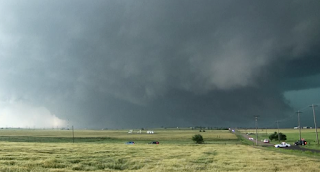
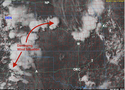
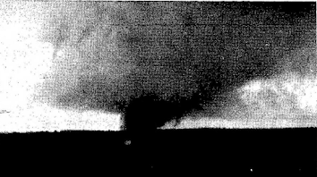
There were two important tornadoes for which today is the tenth anniversary.  El Reno, Oklahoma National Weather Service, Joseph Brennan The National Weather Service in Norman has a comprehensive write-up here . This was the largest tornado in recorded history and, per Doppler radar wind measurements, one of the strongest. Between the tornado and flooding, 21 people died.  St. Louis Area YouTube This storm was very tricky for warning purposes but the NWS and local broadcast media did a great job. No one died in spite of extensive damage -- more damage than occurred in Oklahoma -- as the storm was a long-track F-3 tornado as it went across the densely populated North County area. In addition to it being a more difficult than average tornado warning situation meteorologically, the Weather Channel and others were ignoring the St. Louis threat in favor of the Oklahoma City area where they had a "Tornado Tour 2013" crew. They were rolled by the tornado .   If you wish to read my r

Today's Tornado Outlook

Image
The brown area of eastern New Mexico has a significant risk of tornadoes. Please keep up on the latest weather information in this region this afternoon and evening. 

May Rainfall

Image
Here is a map of rainfall for the past 30 days. And, here is a departure from normal map. The drought in the High Plains has been nearly wiped out in some areas. 

High Plains Damaging Winds Developing

Image
The area of thunderstorms (indicated by arrows) in the High Plains has the potential to cause widespread damaging winds. The NWS is forecasting 80 mph winds with these storms as they congeal and move to the east southeast. Power failures are possible.  Hail to 2" in diameter is possible. A tornado has occurred near Lamar in southeast Colorado, but I do not believe the tornado risk is high in this situation.  Please follow me on Twitter @usweatherexpert  for additional updates. 

Getting Sucked Out of Building in a Tornado

Image
Why, if you don't have a basement, you should be in a bathroom or closet in the middle of the house when under a tornado warning.   The woman was sucked out of the building amidst all of the flying debris and other hazards. She is lucky to be alive.  This year is already more active than than any since 2020. Please make sure your family and friends follow the best procedures to secure their safety in tornado situations. 

On This Memorial Day, Please Think About the Sacrifices Made By Others For Our Freedom

Image
Happy Memorial Day, 2023. 

Sunday Fun: Look at the License Plate

Image
I try not to take up the "Florida Man" meme very often but this is a screen capture of a (yes) man driving rather fast down the roadway with the door open and some package sticking out of the back seat.  My advice: As this is a holiday weekend, don't have a few beers and then go shopping!

"It Takes a Flood to Break a Drought"

Image
Meteorologists have long said, "It takes a flood to break a drought." Unbelievable rainfall amounts from the High Plains after suffering from a serious drought the past three years.  Three Day Rainfall Yes, that is more than a foot of rain near Clovis, NM. That is two-thirds of their average annual rainfall!  Interstate 27 between Amarillo and Lubbock has been closed due to flooding.  Seven Day Rainfall Heavy rains have fallen in around Denver and throughout the Colorado and southwest Nebraska High Plains. The heavy rain in southwest Nebraska caused Amtrak's California Zephyr to be rerouted from BNSF at McCook to North Platte on the Union Pacific.  Here is the forecast rainfall for the 5-days beginning at 7pm CDT this evening.  More flooding is likely.  Tornado Forecast Until 7am Sunday And, if that wasn't bad enough, there is a significant risk of tornadoes in the brown area -- which is part of the flooded region. Stay well way -- otherwise, you could be trapped.

The Journalistic Pathology of Climate Reporting in the United States

Image
Dr. Roger Pielke, Jr., an outstanding researcher at the University of Colorado, has written a must-read essay at his Substack site pertaining to all that is wrong (and it is a lot!) with reporting on climate in the United States.  While this is a must read in its entirety, my favorite part is what I frequently mock as, Global Warming: Is there anything it can't do?!"  Samples from Roger below. Of course, all of the above is nonsense.  Today's journalists find it essential to be part of the "progressive team" rather than accurately reporting the news. 

Summer is Peak Flash Flood Season

Image
Turn around, don't drown! The number one cause of fatalities in flash floods is people, who were perfectly safe, driving into flooded areas. The car then gets swept away with sometimes fatal results.  Although not fatal, that is what occurred with each of the autos pictured below. Yes, I know you might save five minutes trying it, but why take the risk?  

Rainfall Forecast for Memorial Day Weekend

Image
Note the heavy rains forecast for the Carolinas, Virginia and coastal Georgia. There is a slow-moving non-tropical weather system off the coast that is forecast to move inland. It is not  expected to develop into a tropical storm.  Elsewhere, localized flooding might occur with slow-moving thunderstorms in the band of rain from Texas to Montana. Unseasonal rains are forecast for the mountains in California. 

The Direction We Are Headed

Image

Today is NOT the 50th Anniversary of the First Doppler Measurement of a Tornado

Image
NOAA has put out a press release, a video and other information claiming today was the 50th anniversary of the first time a tornado (specifically, the Union City storm) was measured by Doppler radar. Except it isn't. The 50th anniversary of the first measurement of a tornado by Doppler radar was June 10, 2008; which occurred when an experimental Weather Bureau Doppler radar based in Wichita measured the F-4 El Dorado Tornado. That storm killed 13 people on June 10, 1958. 1958 Experimental Doppler Radar at Wichita's Mid-Continent Airport  The peak measured speed was 206 mph. It is hardly as if that tornado and its Doppler measurement is a secret. It was written up in the peer-reviewed journals.  Happy to correct the record. 

Global Warming: Is There Anything It Can't Do?!

Image
The article is so silly, I'm not linking to it.  Lower income countries are also heavily affected, which Obradovich hypothesizes could be because of a lack of air-conditioning. But he plans to investigate further. It, of course, measures people without air conditioning or room coolers. The latter can be purchased from Amazon for less than $100. Problem solved!

Heads Up: Georgia and Coastal Carolinas

Image
There is a system that will drift into the Georgia and coastal Carolinas that will intensify a bit causing heavy rain and gusty winds. Keep an eye on the weather this weekend.  The map is rainfall. 

Today's Tornado Risk

Image
The area in brown has a significant risk of tornadoes. This includes Clayton, Tucumcari and Clovis. Please pay attention to the weather this afternoon and evening.  Giant hail is also possible in the brown area. 

YES!! Move The Government Out of Washington, DC!!!

At American Greatness , Roger Kimball in a piece published May 20 writes to the next Republican president, whomever he/she may be: Washington really is a swamp and it will consume you. And here are a few particular bits of advice:  1) Have the inauguration in Mar-a-Lago (if it is Trump) 2) Govern from Florida as much as you can.  3) If you decide to indulge in the theater of the State of the Union Address as it has evolved, deliver it from, say, Kansas.  4) Disband the FBI. We should never have allowed a national police force to come into being.  Move the bits of the government you can’t actually destroy to other parts of the country. Do these things instantly—the day you take office. The deep state will howl. The bureaucrats will oppose you. The lawyers will sue you. Do it anyway. Act first, deal with the consequences later... The focus should be on eclipsing Washington, D.C. as the seat of government. It has long been obvious to candid observers that there is something deeply dysfunc

Sale and New Review of "Warnings"

Image
I just noticed a new review at Amazon: This gentleman liked Warnings so much that he purchased it as an ebook and then bought the hard copy book.  As of 7:37pm this evening, the price was just $17.53 . That is quite a discount!

Major Typhoon Headed for Guam

Image
C = center of Super Typhoon Mawar which is headed straight for Guam. Peak gusts of 200 mph are forecast to occur later today. It will be the worst typhoon in at least 20 years.  The radar image is from 5:27pm CDT.  

Outlook for Memorial Day Weekend

Image
Here is a preliminary outlook for the Memorial Day Weekend.  Temperatures will be seasonal with no areas of extreme heat or cold. Here is a map with Saturday's forecast high temperatures.  Enjoy the holiday weekend but keep in mind the sacrifices made by the members of our military for us. 

12th Anniversary of the Joplin Tornado

Image
An unfathomable tragedy occurred 12 years  ago today.  One of the worst tornadoes in United States' history occurred on this date in 2011. It was an EF-5 intensity storm and that ferocity, when combined with it striking a densely populated area, would inevitably lead to a huge number of deaths.  But, it became the worst tornado of the tornado warning era because the tornado warnings and emergency management's siren activations were botched. Since the approaching tornado was behind a curtain of rain and could not be seen, the people of Joplin were sitting ducks. A total of 161 mothers, fathers, daughters and sons died, many unnecessarily.  National Weather Service What makes it even more frustrating was that this was a straightforward warning situation. A hook echo with increasing rotation produced by a right-moving supercell thunderstorm which formed in southeast Kansas and moved east across the city. See below.  Yet, the NWS, time after time, misstated the direction of the st

Review of "Without Warning"

Image
Review of   Without Warning: The Tornado of Udall, Kansas   by Jim Minick I had so looked forward to reading this book from the time I first heard about it, I pre-ordered it from Amazon with overnight shipping. I have been fascinated by the meteorology of the Udall Tornado for years and recently submitted a possible correction to the tornado paths that night to the NWS Storm Prediction Center. But, my work has been exclusively scientific and I wanted to learn more about the human side of the disaster.     I’m sorry to report that I cannot recommend  Without Warning  because of the large number of factual errors it contains. These errors are not just meteorological, many are just sloppy. For example, Wichita is not “near” Sedgewick [sic] County, it is  in  Sedgwick County. He calls the Wichita Weather Bureau office in 1955 the National Weather Service (it was “Weather Bureau” until 1970) and, in references after that date, it is often, and incorrectly, called “NOAA Weather Station.” The

This Week's Rainfall

Image
This is the NWS's forecast for rainfall from now until 7am CDT next Sunday. I'll provide a Memorial Day outlook on this blog at midweek. 

Sunday Fun: Come Visit Wichita!

Image
Yahoo! Wichita has been named a Top 5 travel destination for this summer.  Per WalletHub, Wichita is the #4 place to visit this summer. If you come, I promise you will receive a warm welcome. For a partial list of things to do, click here . 

Global Warming "Gaffe:" When a Politician Tells the Truth

Image
Yes, they are due to 'climate change,' specifically the offshore wind turbines they have installed to fight global warming. The wind turbines do almost nothing to cut CO2 emissions but they are a great foundation for graft. 

Anniversary of the Ruskin Heights Tornado

Image
Today is the anniversary of the 1957 Ruskin Heights Tornado. That F-5 tornado killed 44 and injured more than 300.  Life  magazine This monster tornado ushered in governmental tornado warnings (they had been invented by WKY-TV in Oklahoma City a few years prior) and it was the day that utterly changed my life. The above photo captures the horror. Not only had the couple lost everything, note that the house was stripped to the floorboards. That's what it looked like -- home after home of nothing but the floor and, perhaps, a commode or pipe spouting water. Homes stripped to the floorboards upper right.  Destroyed gymnasium at what was the new high school. For me, the tornado not only set me on my career to be a meteorologist, it played a role in me meeting and dating Kathleen and even where we would marry. Below is a photo of the original Martin City United Methodist Church. It was so heavily damaged it had to be torn down. We were married in the replacement church. The tornado had

Ahh, But Read the Fine Print!

Image
Yesterday's Wall Street Journa l   had an article about our hapless and increasingly dangerous federal government taking 17 years to approve a wind energy project under a "fast-track" program.  But, I want to bring some of the article's important fine print to your attention. It says, "the permit allows the developer, Pattern Energy, to build the country's largest wind energy project across three counties in rural New Mexico and deliver that electricity to large markets in Arizona and California." Wait, what?! Forget killing eagles and rare birds, forget killing endangered whales (via off-shore wind), forget rising rates and making the grid less stable by the year: the people who have to look at and hear these monsters won't get any benefit from them?! And, who is going to pay for them? In Kansas, ratepayers are being required to fund an expensive transmission line like the one above that will send wind electricity generated in the Sunflower State to

On Drought Conditions in the Central Great Plains; Huge Hail in DFW

Image
Wichita Eagle this evening In most of the west half of Kansas, the wheat will be plowed under. With the drought there, and in parts of central Kansas, the wheat isn't worth harvesting. Here are the drought conditions as of Tuesday in the central Great Plains.  Since Tuesday; here is the rainfall to 6pm Friday. As much as eight inches fell just northeast of Amarillo ("A").  The scale is at right. Green is at least .75 inches. Yellow is at least 2.5 inches.  And, farther south, there was damaging hail in a small part of the DFW Metroplex.  The small deep purple areas surrounded by pink = 3" diameter hail (75 millimeters, see scale at right).  There are reports of considerable damage near Allen and in this swath.