Posts

Showing posts from November, 2023

7:05pm Tornado Risk Update

Image
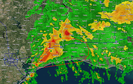
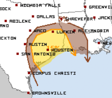
The 7pm radar shows a cluster of strong thunderstorms getting ready to cross from Texas into Louisiana. The red outline is where the NWS SPC still believes there is a chance of tornadoes during the next couple of hours. There has been mild rotation in the cluster from time to time. There is also a flash flood risk.  During the rest of the evening and into the overnight hours, there is still a small risk of tornadoes in the brown area in Louisiana. 

Tornado Risk Over For Houston and Points West (6:05pm)

Image
This forecast has been updated, please scroll up.  The area of thunderstorms has moved east of Houston. I believe the risk of tornadoes has ended for the area.  However, there is still a chance of a tornado or strong winds in far southeast Texas and southwest and south central Louisiana.  Please remember, I also provide additional severe weather warnings on X/Twitter: @usweatherexpert. 

Good Riddance!!

Image
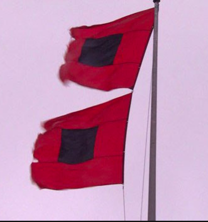
Today is the final day of the 2023 hurricane season.  And, for the 2024 season, there is some new research that might prove helpful in forecasting the "rapid intensification" of hurricanes. There are some hurricane forecasters that believe 2024 could be a very active year. You may wish to factor that into your plans for next summer and autumn. 

10:45am Thursday Update: Tornado Risk For Texas and Louisiana

Image
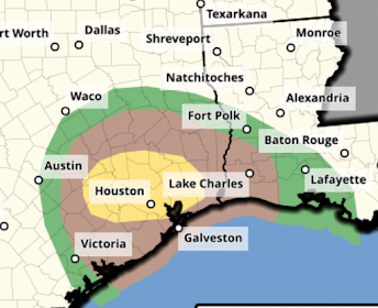
The NWS SPC has significantly revised its tornado forecast for this afternoon and evening.  The brown area has a significant risk of tornadoes. And, the forecast area has been extended east into south central Louisiana.  Note: the issue with the NWS's primary radar being down will continue for the next few days. However, I will be using the FAA's Terminal Doppler Weather Radars (there are two) known as TDWR's to cover the area as well as the NWS's radars at Lake Charles and Ft. Polk. To reassure you, I have posted a sample image of one of the TDWR's below.  Please ignore those on Twitter complaining of inadequate radar coverage today. Some meteorologists and aficionados do not have access to these radars. 

Extreme Snowfall in the Cascades

Image
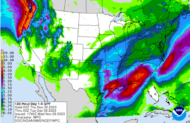
Tremendous amounts of snow will fall over the Cascades that will help break the persistent drought in the region. Over the next seven days as much as 20" of water may be contained in the feet of snow. 

Texas and Louisiana Tornado Risk Today

Image
This forecast has been updated. Please scroll up for the latest.  There is is an enhanced  risk of tornadoes in the yellow area which includes Houston and The Woodlands. The brown area has a significant risk of tornadoes which includes Galveston, Beaumont-Port Arthur-Orange and Lake Charles.  Note: The primary NWS radar for southeast Texas is inoperative due to maintenance. However, I have access to the two Federal Aviation Administration radars that do a fine job in locating tornadoes. I have an example below from 8:29am. So, please follow me on Twitter @usweatherexpert  for updates. 

A Small, But Messy, Winter Storm

Image
I promised an update on this storm. Right now, it appears the forecast locations are approximately correct but amounts are a bit on the high side. [10:15am Thursday] Total Snowfall I've spent more than an hour looking at the raw data and this particular model looks like it has a good handle on the situation. That said, keep in mind a band of snow can aways shift a bit in any direction.  Total Freezing Rain This model often exaggerates the amount of freezing rain. However, its placement is usually pretty good. I would divide the amounts by two.  Because this is a rather complicated situation, I've provided snapshots of the forecast radar to give you a rough idea of the timing of the snow and ice. Forecast Map for 8pm Thursday Please recall the darker the blue, the heavier the rate of falling snow. Green is rain and yellow/red are possible thunderstorms.  Forecast Map for 2am Friday Red is freezing rain, the darker the heavier rate of rainfall.  Forecast Map for 7am Friday At thi

Heavy Rains in the Northwest and South

Image
While the rains will be heavy in the Northwest with as much as seven inches predicted over the higher elevations, the flood threat will be mitigated by the dry conditions in recent months (see below).   In the South, there are also drought conditions which will mitigate the flood potential. There is a good chance of snow and/or freezing rain in the Midwest. I'll post separately on this threat in the next couple of hours.  Palmer Drought Index as of the 23rd The deeper the reds, the drier. The deeper the blues, the more wetness is being experienced. 

Texas Tornado Risk Thursday

Image
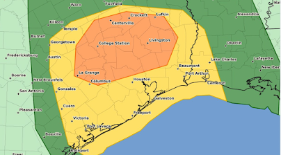
This forecast has been updated. Please scroll up.  The orange area has an enhanced  risk of tornadoes. This includes The Woodlands as well as the cities listed on the map.  The yellow area has a significant risk of tornadoes. This includes Lake Charles and far southwest Louisiana. 

To Complete the (Climate) Picture....

Image
Last week, the Kansas City Star  ran a story about about the depletion of the Ogallala Acquifer. It is serious problem for Kansas and surrounding states, especially as it pertains to agriculture. The article talked about the recent drought in western Kansas that -- thankfully -- broke last spring.  As it was not mentioned in the article, we thought it was worth noting that, with our changing climate, western Kansas, on average, is getting significantly wetter.   Below are the rainfall graphs from the National Weather Service offices at Dodge City and Goodland. I've looked five other western Kansas weather stations and they all say the same thing -- wetter.  The same is true in adjacent areas of Oklahoma and southwest Nebraska. This is completely at odds with a computer model study that said western Kansas will get drier.   While I am entirely in favor of a reasonable plan to conserve the underground water supply, Mother Nature's help is most welcome.  In spite of what you hear

Climate Hypocrisy Conference Begins in Dubai Thursday

Image
The reason you are hearing so much about global warming and its (often supposed) effects these days is because it is hype prior to the COP 28 climate conference in Dubai which begins November 30. Big Climate wants to build support for draconian measures to "save the climate." Unlike, say, Denver (very close to Boulder, home of hundreds of climate scientists), Dubai is hardly a hotbed of climate research. Virtually all of the thousands of participants will have to fly -- putting thousands of unnecessary tons of CO2 into the air. All of this could be done over Skype. That stated, Emirates Airlines made a very cool video welcoming people to Dubai about 1.5 years ago. It is below.    And, another cool video shows how the above was made.  That said, it is the height of hypocrisy for tens of thousands to fly thousands of miles to Dubai to tell the rest of us to cut our carbon footprints. 

Charlie Munger, Rest in Peace

Image
Wall Street Journal Charlie Munger, who began his career as a meteorologist in World War II, has passed away . In fortuitous event, Charlie met Warren Buffet and the two became fast friends and business partners. Their Berkshire-Hathaway became one of the most successful enterprises in history. Unquestionably, he made more money than any other meteorologist in history.  His focus on what was important in meteorology, an innovation during World War II, was a turning point in our science. I strongly suspect that same focus proved invaluable in his investment career. 

'Green' Energy: The Graft Continues

Image
There is even more graft than I estimated. This update is as of 7:10pm Thursday, the first day of the conference. $4 Trillion!!! --- original posting --- I am presenting three articles over the next two days in advance of the gigantic global warming meeting in Dubai. They will help provide context in view of the often slanted coverage of the MSM. We often talk about how the primary sources of propulsion for the global warming movement are 1) power, and 2) cash ... with graft often lurking as part of #2. Here's the latest scam in the form of solar energy contracts. The title of the piece? The Green New Steal . Just this morning, Instapundit.com  published a piece on the Administration's graft  "green" energy loan department that 'invests' huge sums of our money in hugely risky enterprises (some run by politically well-connected individuals) many of which have failed .  While on the subject of graft, consider the giant climate meeting that begins in Dubai on Thu

Texas - Louisiana Tornado Risk Thursday

Image
A potentially unusual line of thunderstorms is forecast for Thursday over east Texas (including Metro Houston and Bryan-College Station with tornadoes starting in the morning  and then reaching Louisiana (including Lake Charles) later in the day.  I'm going ahead and alerting about this situation now given both the unusual time of year and the morning risk -- a time of day when tornadoes are infrequent. Of course, I will update this tomorrow and Thursday.

Do You Need Stock Photography?

Image
...if so, I hope you will check out my collection, here . And, please be sure you look at both pages ( link at bottom of first page). 

Another Major National Weather Service Miss

Image
Because I wanted to concentrate on providing our readers with the best possible Thanksgiving weather information, especially for those traveling, I did not comment on an awful National Weather Service (NWS) forecast made this past Tuesday. I want to take a moment to do so now.  National Weather Service Hazards Map The NWS portion of the product is at the bottom, NWS Hazards Prediction (defined at 4" or more regarding snow) for 3 to 7 days in the future. The forecast was valid from this past Friday through the weekend to the 28th (Tuesday). The NWS was not  forecasting any snowfall amounts of 4" or more anywhere in the Lower 48. As you see, I wrote "I strongly disagree" at the top. T he forecast on this blog , posted 2 hours earlier than the NWS's, clearly forecast heavy snow in the central Great Plains and Rockies: That heavy snow would fall over this region was a straightforward forecast. That the NWS would blow it this bad -- during the #1 holiday weekend for

Essential Reading: Terrifying Report About the State of U.S. Energy

We've written about the terrible issues with the electric grid in the East just before Christmas, 2022. Now, a new report is out that discusses how close we came to a catastrophe not only involving electricity but also involving natural gas.  On Christmas Eve (2022) morning, the five interstate natural gas pipelines serving Con Edison began experiencing drops in pressure at Con Edison’s citygate due to production losses and operational issues. The pressures declined precipitously and at noon, the pipelines informed Con Edison that they had exhausted their line pack and storage withdrawals, and pressures would not improve until demand decreased... Had Con Edison’s citygate pressures not recovered,  it was in danger of losing pressure on, or needing to cut service to, all or large portions of its system. Even losing service to 130,000 customers would be considered a major outage and could have taken five to seven weeks to restore , depending on the availability of mutual aid. Had it

Satellite View of Snow Accumulation

Image
White = clouds and fog while turquoise is the newly fallen snow from yesterday's storm. 

Travel Weather Forecast

Image
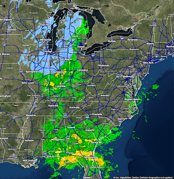
Radar at 10:15am CST Forecast Weather for 6pm CST

Sunday Fun: Don't Know Much About Geography

Image
ESPN Friday certainly don't know about geography....

Moisture Amounts for Winter Wheat

Image
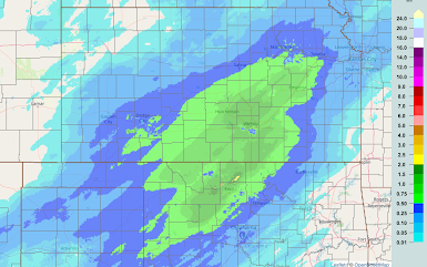
As of 8pm CST, here is the rain gauge + radar estimations of the amount of water contained in the snow. This snow is, by far, the best thing that could happen to the 2024 winter wheat crop.  Snow amount maps, with overlap, are below.

6:56pm Travel Weather Update

Image
Pretty snow in Wichita this evening. We have about 3" in the far northeast part of the city. Five inches officially at Eisenhower National Airport on the far west side. More than 6" in northern Sedgwick County.  Radar at 6:50pm.  The snow continues to move northeast  Snow continues to fall at Bill Snyder Family Stadium where kickoff for Farmageddon will occur in a few minutes.  Dot = location of the stadium. It is 26° there. 

Travel Update: 5:20pm Saturday

Image
While their message was not entirely clear, I believe that most arrivals and departures from Wichita's Eisenhower National Airport will be cancelled after 6pm.  Radar at 5:15pm.  Here is the travel forecast for Sunday. 9am Midwest Radar Because of deicing requirements there could be some flight delays at the Chicago airports as well as at Milwaukee, Madison and Grand Rapids.  6pm Sunday This will be the last national  travel weather forecast for this year.  I'll continue to provide regional updates as long as necessary. 

Travel Weather Update - 4:15pm Saturday

Image
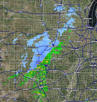
Radar as of 4:12pm As of 4pm, KanDrive is still reporting the Turnpike/I-35 is closed in the Flint Hills due to accidents in the icy conditions. However, as earlier forecast, the ice is shrinking in Kansas and being replayed by snow. The precipitation is moving northeast.  I am expecting an additional 2-3" in Manhattan where Farmageddon is being played with a 7 o'clock kickoff.  Note the small area of 3-5" forecast just east of Emporia along I-35.  Forecast Radar at 10pm Forecast Radar at 8am Sunday Note: I invite you to refer these forecasts to your friends or relatives who might be traveling. 

3:20pm Travel Weather Update

Image
The Kansas Turnpike/I-35 in the Flint Hills is closed southbound due to icy conditions and a traffic accident(s).  The 3:15pm radar is below. The orange is freezing rain or sleet. The precipitation is moving from southwest to northeast.  If you are going to Farmageddon (Iowa State v Kansas State) in Manhattan, make sure you allow plenty  of time. If you know how to read a weather map, the 3pm (courtesy @NWSSPC) surface data + radar (gray) is below. Click to enlarge.  The forecast radar for 8am Sunday is below. The snow should be light.  Below are NWS warnings as of 3:25pm.