Posts

Showing posts from January, 2024

At Least Eleven Days of Heavy Rains

Image
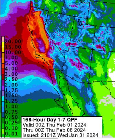
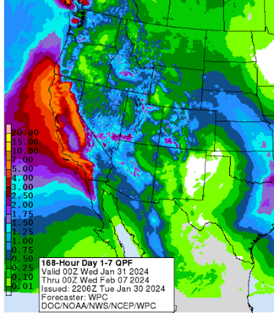
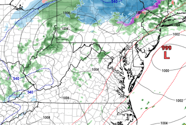
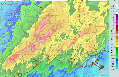
8:30pm PST:   I've taken a quick look at the latest model information and it does nothing to assuage my concerns. This has the possibility  of storms of the intensity of those during the winter of 1982-83. Preparations are needed in the Southland. I'll have more tomorrow.  I continue to be quite concerned about the likelihood of flooding in California.  The map below depicts rainfall the next seven days. Note there are multiple areas where ten inches or more (yellow) are forecast to fall. For Southern California, this may be the most serious rainstorm (with possible thunderstorms and/or flash flooding) in a number of years.   The first of several weather systems is now affecting the northern two-thirds of the state currently. The radar is below. This evening and tonight, some flash flooding may occur in and near the coastal mountains from the Oregon Border to Vandenberg AFB. Radar at 2:10pm PST The most powerful of the storms will strike over the weekend, making it into the Sou

Great Advice From Pecos Hank

Image
Pecos Hank is a storm chaser for whom I have a great deal of respect. He offers some safety advice as the 2024 tornado season approaches.  Click on "read more" to watch the video. And, by the way, I do not recommend storm chasing for non-meteorologists. 

The Heavy Rains in California Begin Tonight

Image
Over the next seven days there will be multiple waves of moderate to heavy rain moving across the entire state and, like last week, will bring rain into the northern Baja.  There are numerous  areas where more than seven inches are forecast to fall over the next seven days. Of course, there will be choking snow in the higher elevations of the Sierra.  The latest radar (5:15pm) shows the rain starting to move in.  If you live in a flood-prone area, I urge you to prepare for flooding. 

If We are Going to Have Wireless Emergency Alerts, Could We At Least Make them Easily Understandable?

Image
We drove between Kansas City and Wichita this afternoon and when I arrived, I found the Wireless Emergency Announcement (WEA) that you see below. The only problems: I don't know what city this is for. My phone didn't "siren," it doesn't tell me what city, nor does it tell what time it was sent. This program always seems to be half-done.  I do not understand why the Federal Communications Administration and the emergency management community, in spite of numerous complaints from a wide variety of users (mentioned on this blog many times, one example: here ), can't get their act together and fix these. After all, tornado season is coming up. 

Seven-Day Precipitation

Image
The switch to the wet pattern on the West Coast is underway. If you note, those are extreme precipitation amounts with as much as ten inches in several locations in California.  The snow will generally be confined to higher elevations because there is little cold air around the United States. 

Pledge of Allegiance... to Stymie Global Warming Speech?

Image
There are noble pledges like the Pledge of Allegiance and pledges that can be evil (like fictional one above from the movie  Blazing Saddles) . But, it is nearly impossible to tell which is which if we can't know the content of the pledge.  In Baltimore tomorrow, Tuesday, at 11:40am, the American Meteorological Society (AMS) is evidently going to enter into and sign a "pledge" with major news organizations and various "scientific" organizations from around the world. From the AMS's announcement, here is a list of science organizations: I don't know anything about the "More..."     Also, other than one of the sponsors, EarthX TV, it does not list which media organizations are signing the pledge. Brad Colman, the President of the AMS, says,   "Tackling the challenges of climate change requires participation across all of society, yet in today's information environment,  it can be difficult to distinguish what claims are evidence-based ,&

Note to Readers: We Aim to Please

Image
For those who were missing the Archive we had with our previous blog design, it has been relocated. Just click and you will see all recent article. 

HAPPY KANSAS DAY: How a Kansan Handled Anti-Semitism

Image
Today is Kansas Day, the anniversary of Kansas being admitted to the Union as a free state. I thought, given events in the world, this story of a Kansan and anti-semitism was appropriate.  At the U.S. Capitol, each state has two statues representing their citizens.  Kansas' statues are Eisenhower and Amelia Earhart.  General Dwight Eisenhower, who grew up in Abilene, Kansas, was utterly shocked by the death camps Hitler created during World War II. As commander-in-chief of the allied forces, he gave these orders after touring Buchenwald: ...Eisenhower was shocked after seeing one in person and realizing what that system actually was. He recognized that this was what his men were fighting against, that liberation was more than just freeing territory – it was about the very survival of civilization itself against a barbarism few had thought existed in the heart of modern Europe. Eisenhower issued a series of orders. The camps were to be documented, photographed, and filmed. Survivor

Chiefs Going to the Super Bowl!!

Image
Year after year, the Chiefs get underestimated (we were 4.5 point underdogs in this game) and we come through. I posted the forecast before the game and a Ravens fan made a prediction.  Click on "Read More" to enlarge to see the comment. SZN, keep your day job and don't get into forecasting the weather or sports. 

This Week's Precipitation and Drought

Image
Forecast for This Week's Precipitation Valid Until Next Sunday The current storm track is across the southern USA, which means dryness in the northern U.S. will worsen with time. Below, is a drought condition map as of this past Tuesday. 

This Certainly Makes Me Want to Use Less Fossil Fuel. How 'Bout You?

Image
Climate zealots threw soup on the Mona Lisa today. The video seems to indicate at least some museum officials knew of or anticipated the attack as they were ready moments later to put up screens so visitors could not see what these activists had done. 

10:30am Forecast for Chiefs v Baltimore

Image
Forecast Weather Maps for Kickoff at 3pm EST There will be scattered showers during the game. I do not expect any lightning.  Wind will not be much of a factor.  Temperature of 43° at kickoff.  Temperatures will stay in the low 40's until the game ends.  There will be no weather issues for the Detroit at San Francisco game.  If there are any major changes, I will Tweet them @usweatherexpert.  Go Chiefs!!

Sunday Fun: SNL on Alaska Airlines

Image
One of the best pieces SNL has done in a long time.  And, if you think a plug-door coming off was scary, trying flying Alaska to the North Slope to land a 737 on the tundra. Been there -- and, don't want to do it again!

Chiefs Forecast

Image
Here is the forecast radar at kick-off tomorrow in Baltimore. At 3pm Eastern (kick-off), the temperature should be about 39° with the temperature more or less steady during the game. I disagree with the forecasts calling for continuous rain. I believe there will be a few showers but it will rain a minority of the time.  The weather in Santa Clara for Detroit v San Francisco should be nice.  And, just for fun, here is the original "Chefs" commercial. Regardless of whether it is the Chefs or the Chiefs, I look forward to a great game tomorrow!

How the National Transporation Safety Board Chair Operates

Image
Today's Wall Street Journal  has an article about the current chair of the National Transportation Safety Board (NTSB) operates behind the scenes.  As many of you know, the NTSB has been amazingly successful at making aviation and all types of travel safer. I would like the proposed Natural Disaster Review Board to be modeled after the NTSB in most ways. 

Some Wonderful News

Image
While COVID temporarily stopped progress, this is unbelievably good news. While there is still a ways to go, as Dr. Lomborg shows as recently as the 1980's, 40% of the world is extremely poor. Now, 8.6% of the world. 

Precipitation Outlook Next Ten Days

Image
Here are the forecast rainfall amounts for the next five days (Wednesday evening). I have higher than average confidence in the 6-10 precipitation amount forecast.

Note to Readers....

Image
For my stock photography customers, 11  new photos were added to the collection in the last 48 hours. The new photos are on the second page (click on "2" at the bottom). 

The Upcoming Eclipse and Average Cloudiness

Image
With the total solar eclipse coming up April 8, you may be wondering where the best place to view the eclipse may be? Here is an average cloudiness map created by the University of Wisconsin's Space Science and Engineering Center.  The red colors are the area where clouds are least likely. The darker grays, the most likely. Of course,  on any given day, the weather may vary considerably from the average. As the eclipse approaches, I'll update you on the odds. 

One Less Thing to Be Concerned About

Image
New York Times Saturday, the  New York Times   published an op-ed from an academic expressing fear the public will not be able to obtain quality weather and climate information in the future. Having spent 53 years in weather and climate science, I’m not aware of a single person or organization who would argue the public should not have access to weather and climate information. It is entirely a non-issue.  But, let’s take the story seriously as the average  Times  reader may have read it and now has questions or believes there is a genuine concern.    The ”people won’t be able to get their weather information” concern has been covered dozens of times since the late 1930’s (when Dr. Irving Krick began charging movie companies for specialized weather forecasts -- the first known commercial meteorology in the United States).   The  Times  article quotes my former boss, Dr. Joel Myers, but unwittingly makes a point opposite of what was intended: Joel was referring to the 2007 EF-5 Greensb

Incredible Rainfall Amounts - Flood Update

Image
From east Texas to Mississippi torrential rains have fallen. The reds are amounts of 7" or more over the past two days ending at 5pm. There are numerous flood warnings out.  In the dark blue region, "considerable" flooding is forecast to occur the next three days. The dots represent flood levels of major rivers. Gold is minor flooding. Red is moderate flooding and purple is major flooding.  The light blue is "limited" flooding and will extend to southwest Pennsylvania. 

Tornado Risk Update: 3:30pm Wednesday

Image
The atmosphere ahead of the line of thunderstorms departing Mississippi is not particularly conducive to tornado development.  Below is the 3:27pm radar. I have circled the area where there is a slight  chance of a tornado. Because any tornadoes are likely to be on the weaker side (remember, all tornadoes are dangerous), I do not believe a tornado watch will be issued. The chance of a tornado will shrink to virtually zero after sunset. 

Flood Outlook Today -- Updated 12:14pm Wednesday

Image
Increased risk of flooding this afternoon in the scalloped area, 12:10pm.  --- Original Posting --- The red area has an enhanced risk of flash flooding today and tonight.  The yellow area has a significant risk.  Below is the rainfall during the past three days until 11am. More than ten inches have fallen in east Texas. Below is the additional rainfall forecast between now and 4am.  Remember: never try to cross flooded areas by foot or by car. 

Flash Flood Safety Recommendations

Image

Updated Flood Forecast for the South; 7pm Tuesday

Image
The forecast below is still valid. However, during the night (till 6am Wednesday) there is a moderate risk of flash floods in the red area. Parts of the red area have already had 7" of rain. Here is the updated flood outlook from the National Weather Service: The dark blue area is where "considerable" flooding is expected. The light blue area is where "limited" flooding is forecast. The timing is from now to Friday.  The dots represent forecast stages on the major rivers. Orange is minor flooding and red is moderate flooding.  For the last three days ending at 2pm, there are isolated six inch amounts to the north and south of I-20 in Texas (just west of Shreveport). That is enough to create flooding by itself.  Additional rain is occurring in the area as of 2:42pm.  Parts of that area around Shreveport are already under a flash flood warning (green polygon). Unfortunately, more rain is on the way. Below is the rainfall amount forecast from 6pm this evening unti

Heavy Rains Beginning in the South Central U.S.

Image
Updated Forecast HERE The threat for significant flooding in the south central states is being realized this a large area of thunderstorms and shower with heavy rains has developed. If you live in a flood-prone area, you will want to prepare for the potential for flooding.  The medium green is a flash flood watch., The bright greens are rivers already or soon-to-be in flood. The gray is dense fog advisories.  The radar at 10:18am. The storms are moving northeast. They should grow in size during the day and tonight.  The forecast map is for rainfall amounts. The amber inside the orange is a forecast for 7-10 inch amounts. 

Update on the Maui Wildfire

Image
Over the past week, a lot of complaints pertaining to the Maui Wildfire aftermath have been received. This tweet from yesterday evening is pretty typical.  Note the sentence I highlighted in red. This is exactly why we need a Natural Disaster Review Board !  The NDRB will determine what went wrong and how to fix it in Maui and elsewhere.  The National Transportation Safety Board has made amazing contributions to transportation safety. The United States  -- desperately -- needs a similar organization given the proliferation of disasters in our nation. Please contact your congresspeople and inform them of your support. 

Major Flood Threat: California!

Image
This was Interstate 5, the major north-south freeway in California, in San Diego earlier today. Major flooding occurred in the area.  Brandon Wright-Rowan, via NWS There was major flash flooding in the San Diego Metro today.  Radar showed an east-west line of thunderstorms that caused as much as 3.5" of rain in the mountains, which occurs only about once every dozen years. At the airport, 2.7" of rain fell -- making it the 5th wettest day in history at the airport.  Unfortunately, the weather pattern setting up for California is going to transition the state from "moderately wet" to "flooding likely." The rainfall the next seven days will be nothing remarkable (see below). The NWS's 8-14 day rainfall forecast calls for extremely high confidence in a wetter-than-normal forecast. This weather pattern may continue beyond day 14.  If I was a resident of California and live in an area where flooding has historically occurred, I would make preliminary prepar