
Early Thanksgiving Travel Outlook


--- The Forecast ---
Noon Saturday
No major travel issues expected anywhere except for the snow showers along I-80 in the Sierra and a few snow showers along I-40 in far eastern Arizona.
2pm Sunday

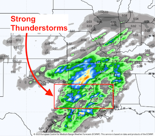
There will be seasonal snow showers in the areas of the west along I-90 and I-70. In the central U.S., all of the precipitation will be in the form of rain except near I-35 from Wichita to Dallas and about 75 miles on either side of that highway. There, thunderstorms with hail and wind gusts of 50 mph or stronger are possible. 
8pm Monday
 All of the precipitation (rain) will be in the form of rain except in the outlined area where hail and strong winds may occur with any thunderstorms.

Beginning Saturday afternoon, I will have forecasts from Thanksgiving, forward.
Preliminary Outlook for Friday-Saturday-Sunday After Thanksgiving
 While this is very preliminary, I wish to make my readers away that temperatures will tumble east of the Rockies to well below normal levels. The blue indicates where accumulating snow might fall. It is too soon to get very specific but you may wish to factor this into your plans.
Preliminary Outlook for Friday-Saturday-Sunday After Thanksgiving


Comments
Post a Comment