
Post-Thanksgiving Travel Weather - 3pm Thursday
We've had beautiful weather across most of the nation for our Thanksgiving celebrations today. Hope you are having a great one!
 It is going to be a real mess in the central High Plains, the Rockies and the Intermountain Region. I-80 and I-70, especially, along with I-25, I-76, and I-15 are going to be hazardous depending on what highway crews are able to do. Snow will interfere with flight operations at both the Delta hub in Salt Lake City and the Southwest + United hubs in Denver (1-2" forecast for DIA). If possible, ask to be rerouted around the storm. For example, if you are flying on United from Louisville to Vegas and are changing planes in Denver, see if they will re-route you to change planes Chicago or Houston.

 Above is the forecast radar for noon Central time on Saturday.
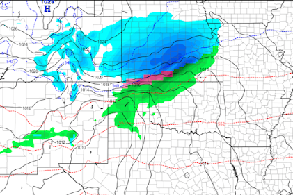 There will be lingering snow in Denver that may still cause a few delays. Wichita's Eisenhower National Airport will likely have delays and may see some cancellations (2-5" forecast to fall). The maroon from southwest of Wichita into the Oklahoma Panhandle might see some freezing rain but it is more likely it will be rain or snow. There will be some light snow that will fall at Kansas City's International Airport Saturday night but the effects should be minor.
 It is exceptionally difficult to forecast final snow depths given the warm ground temperatures. The band of 1" sows from Kansas and Des Moines to Milwaukee, Chicago and Grand Rapids is only expecting 1-2 inches.
Unfortunate, for many, the return weather will leave a lot to be desired. Please consider these forecasts while making your plans.
Noon Friday

From AccuWeather, the time of arrival of the snow.

Noon Saturday

5pm Saturday

Below is the forecast snowfall (as opposed to accumulation):


Comments
Post a Comment