
How Did Yesterday's Forecast Work Out?
Forecasts of derechos and damaging winds can be difficult and I've busted a couple this year.
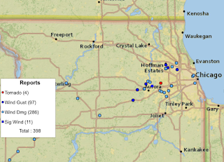 There was one report of a tornado.
However, yesterday's turned out to be quite accurate.
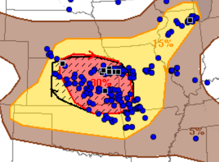 The blue dots are wind reports of 60 mph or stronger. The black squares are winds 75 mph or stronger. The strongest in Kansas were 89 mph in Shawnee and 85 mph in Yates Center. Power outages have been extensive in these areas: 103,000 homes and businesses (~300,000 people) are still without power in Kansas and Missouri.

There were also high wind-producing thunderstorms in Chicagoland.


Comments
Post a Comment