Posts

Showing posts with the label storm chasing

The National Storm Chaser Summit Just Ended

Image
The 2025 National Storm Chaser Summit ended earlier today in Overland Park, a suburb of Kansas City. It was a huge success with educational sessions, interesting company sponsors (yes, that's is a full-size tornado siren below) and -- for the first time -- a session for students and their parents for kids interested in meteorology. I met students from as far away as Tennessee.   TV news story chase vehicle. Behind it is a mobile Doppler radar.  Not only did we learn a lot, we got to meet the next generation of meteorologists and storm chasers.  I'm with Alex, a brilliant young man who will do great things in our field. Over my right shoulder is "the legend," Dave Hoadley. Dave was the very first scientific storm chaser, even before our 1972 meeting at the University of Oklahoma. The range in storm chasing captured in a single photo.  For readers of this blog and my Tweets/X messages ( @usweatherexpert) , I learned several bits of new science which will allow me to do...

Oklahoma Legislature Attempting to Regulate Storm Chasing

Image
Oy! This one is really bad.  Oklahoma Senate Democrat Mark Mann has introduced a bill into the Senate calling for licenses for storm chasers but only those associated with the University of Oklahoma (I sense they are, at least in part, behind this) and TV (not radio or other news media) can be licensed! Worse, the bill allows untrained storm chasers to use the same automotive warning lights used by police and fire! This is just begging for abuse with auto accidents being the consequences.  When we had the National Storm Chasing Convention in Wichita a few years ago, I invited a member of the Oklahoma Highway Patrol to sit with Kansas law enforcement and emergency management to sit with a panel of storm chasers. The OK Highway Patrol officer, Pat Mays, was adamant that they love storm chasers (as long as we drive according to the law) and begged us to call-in real-time reports.  Keeping in mind that a constitution limits governments' powers  (as opposed to the peoples...

Sunday Fun: Kansas City's Map Store

Image
The smiling face above belongs to Pat Carroll, the proprietor of Gallup Map in downtown Kansas City. He is holding a map I purchased from his store as a budding high school meteorologist in the late 19 60 's. I was driving through downtown KC a few weeks ago and was pleasantly shocked to see Gallup Map  Company was still in business. As a high schooler who wanted to be a meteorologist, I often stopped in to buy maps for plotting weather information. For the first time in 60+ years, I visited last week. They still have a great selection of maps, art and related materials. I wanted to purchase a quadrangle topographic map for part of Johnson County and, it turned out, the area I needed was covered by two maps. Patrick used his computer tools to splice the two together and I had exactly what I needed.  Storm Chasers:  He has a great selection of state Gazetteers.  It was great to see a family-operated business continue to flourish after decades in business. 

Comprehensive Update on Tropical Storm Helene; Update 11pm

Image
NHC is now forecasting sustained winds of 120 mph at landfall which would be a strong Cat 3 hurricane. People in Tallahassee should prepare for hurricane force winds.  Next update will be tomorrow morning.  ---- The newest satellite image (6:54pm) shows Helene developing rapidly. This lends credibility to the forecasts and I urge you to follow the safety recommendations.  ----- 5:15pm update below ---- Hurricane Helene is forecast to come into the Florida Panhandle late Thursday with high winds and a major storm surge ahead of the center. Here is a complete update on the storm. Please forward this information to your friends and relatives.  Hurricane Warnings  have been issued for parts of the Gulf Coast of Florida. The central pressure has dropped to 995 millibars (as of 6pm) 992 990 millibars at 8pm and the maximum sustained winds are 50 60 mph. There are also hurricane warnings for Cancun and the northeast Yucatan. The Forecast Path of the Eye of Helene Her...

Pre-"Twisters:" The Origin of Storm Chasing

Image
How did our modern tornado warning program begin? It started in Oklahoma in 1972 with plucky meteorology students and experimental radars. With the huge success of Twisters  this summer and 1996's  Twister before it, it is likely most assume storm chasing has been around forever. Not true! Storm chasing began in 1972 in a classroom of stinky Felger Hall at the University of Oklahoma. Dr. Joe Golden, a scientist with the National Severe Storms Laboratory addressed a meeting of the OU student chapter of the American Meteorological Society.  Joe asked us to chase tornadoes so the efficacy of two experimental Doppler radars could be tested. I was going through some files in my office last week and found the original plans of the storm chase program.  This was well before the era of cell phones. That first season, we spent a lot of time running around Oklahoma under blue skies or cumulus-filled skies -- with few intercepted thunderstorms, let alone tornadoes. But, we lear...

Full Version of Reed Timmer's "Dominator" Tornado Intercept

Image
The Dominator is an armored vehicle designed to withstand being inside a tornado. They made a skilled intercept in Nebraska last week. They have edited the video from several angles (drone, etc.) and put it together. I know some of our readers will enjoy viewing it so.... here you go!

Sunday Fun: Halloween Costumes

Image
The hottest Halloween costumes for 2022. 

Talk About a "Green Sky" Tornado

Image
From time-to-time people talk about a "green sky" with a tornado. This tornado, near I-70 earlier this evening, certainly qualifies.  And, thanks to storm chaser and photographer Freddie McKinnely for reporting the storm! It has been a busy evening in north central Kansas. 

Nice Meeting the Meteorology Students From SUNY Oswego

Image
We were storm chasing Sunday evening and ran into the student storm chasing team from SUNY Oswego, which is a great meteorology school. They were a great group and it was nice seeing them.  It is important for students to do real-time forecasting and actually getting out to experience storms. I'm glad that more and more universities are doing it. 

Tornado Tracks in Oklahoma and Texas

Image
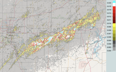
Here are the rotation tracks. Light red, white or blue = likely tornado track.  East of Oklahoma City Southwest Oklahoma and northwest Texas Special attention to this tornado track near Vernon, TX. There was a storm chaser van that was flipped by the tornado when it took the abrupt left turn. It appears to have been in an area of the thunderstorm known to meteorologists as the "Bear's Cage." It used to be an axiom that it was too dangerous to be in the BC, but that seems to have diminished in recent years. Perhaps it is a good rule to reestablish.  Addition below:

1,000 Buildings Affected; No Serious Injuries

Image
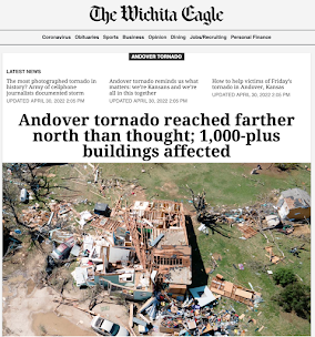
The aftermath of the Wichita-Andover Tornado of 2022 is astounding: One thousand buildings damaged or destroyed and no deaths and no serious injuries. It has a preliminary rating of a high-end EF-3.  Below is the Andover YMCA where the staff heard the warnings and took everyone to the basement. Imagine if the tornado had struck without warning! KAKE-TV News Part of this is good luck. But, the majority is due to weather science training people what to do and then the forecasts and warnings by dedicated and skilled meteorologists.  Congratulations to all meteorologists involved in warning the people of south central Kansas.  Addition: After posting this, it was brought to my attention that three storm chasers from the University of Oklahoma were killed on the way back to Norman last night.  As it turns out, they were chasing the tornado Kathleen and I saw touch down and reported . Meteorologists and storm chasers go into field to report on these storms to keep everyon...

50th Anniversary of "Tornado Chasing"

Image
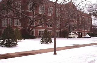
March, 2022, is the 50th Anniversary of Tornado Chasing   OU's Felgar Hall where the meteorology department was located While an amateur meteorologist named Dave Hoadley had storm chased since the 1950's, the scientific storm chasing program began in March, 1972. While I don't remember the date, the meeting of the University of Oklahoma Student Chapter of the American Meteorological Society that month featured speakers Dr.s Joe Golden (NSSL) and Bruce Morgan (Notre Dame). They proposed that students chase tornadoes -- for science.  One of NSSL's two original Doppler radars, 1972 Certainly it wasn't for money! The National Severe Storms Laboratory wanted us to chase all over Oklahoma so as to determine the value of its Doppler radars but they didn't even give us gas money. We were needed to confirm ("ground truth") what the Dopplers were seeing. It was our work that would determine whether Doppler -- far more expensive than traditional weather radar -- ...

Sunday Fun: Pecos Hank's "Tornadoes of 2021"

Image
Pecos Hank is a legendary storm chaser who publishes his movies in an interesting and artistic manner. Here is his summary of the tornadoes of 2021. If you wish to go straight to the action, advance to 1:45.  His YouTube Channel is filled with great videos. My favorite is Drive Under the Moon. Enjoy!

The Most Unusual Tornado Sound Ever Captured

Image
This is may be one of the most important observations made in the 49-year history of storm chasing. It is of a vortex breakdown as a Wisconsin tornado lifted earlier this week. You can hear it, here . You can hear it farther away and from a different direction, here . There is a discussion of what occurred at the first link as well as here .  As it turns out, there was a peer-reviewed paper on this this topic in the Journal of Atmospheric Science  and, based on the science presented, the most likely explanation is that the vortex broke down in a way that caused the winds to exceed the speed of sound for a split second.  For those of us of a certain age, the sound resembles that heard on The Adventures of Superman  when George Reeves landed.  The next time someone tries to tell you there is no value to storm chasing, remember that the observations we have made confirmed the existence of downbursts, the value of Doppler radar and now that this type of vortex...

Jeff Piotrowski's Coverage of Hurricane Laura

Image
Jeff stationed himself in Lake Charles and obtained some tremendous footage. Jeff does this so you don't need to.  Highly recommended. 

One of the Most Amazing Tornado Videos, Ever -- A Candidate For Photogrammetry

Image
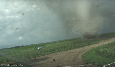
Earlier this month, two major tornadoes occurred in Minnesota. The Basehunters (a storm chase team) posted their 4K video yesterday and there are things I believe are worth bringing to your attention. The first is the ding to the windshield (below). I believe that was caused by flying debris. It looks similar to a bullet strike. That is why we urge you not to take video of a tornado. If flying debris strikes you, you could be killed or seriously injured.  The second is the sound of the tornado. I I've heard many tornadoes and this is the first I've heard that sounds just like a jet engine. If you have ever been on the tarmac of a busy airport, you'll recognize the sound when the photographer steps out of the car. If you wish to watch this segment full screen, click here . This tornado has the strongest, tightest rotation of any tornado I have personally seen or video/film that I have viewed. It would be valuable to know the windspeed of this tornado. On Ap...

Tragedy: Died Taking Video of Tornado

Image
This makes me ill. This is at least the second time a man has died taking video of a tornado approaching. The 2015 video is below. I am posting the above video so that you will be able to tell your friends you have seen what it is like when a tornado approaches and destroys your home. Your curiosity hopefully sated, you won't feel compelled to take your own video in a similar situation. Instead, take shelter when a tornado warning is issued. In the case of Wednesday's tornado, a number of storm chasers took extreme risks which I want to go on the record as condemning. After a fair amount of consideration, I'm going to post the video below. The scene at the end was taken far too close for safety. You will never see closer, clearer video of a tornado  --   so now that you have seen this, there is no reason for you to photograph a tornado at  close range.  It is not worth sacrificing your life and your family to take a video of a tornado!

What I Was Doing 17 Years Ago at This Time

Image
It was May 8, 2003, and the worst conditions in which I had ever storm chased. There were major fires in Mexico and the smoke had been carried into the southern and central Great Plains. I was standing in the rain and small hail while taking this photo while having a hard time seeing the tornado due to the smokey haze. I had to adjust the photo a bit to make the tornado visible. The tornado, at this time, was west of Lyndon, Kansas, and it lifted on the southwest side of Lawrence. The tornado was rated F-3. While there was quite a bit of damage, there were no serious injuries. There were tornadoes all over the Plains and Midwest that day (red dots, below, were tornado locations). The most highly rated tornado that day was in the Moore-Oklahoma City area. It was rated F-4.

Storm Tourism Controversy, Again - UPDATED With Video

Image
Video from inside the overturned van (see below). -- Original Posting -- Photo of violent tornado I took while chasing May 1, 2018 near Tescott, Kansas. As previously mentioned, two vans belonging to Silver Lining Tours were overturned by a satellite tornado as the guests were watching the huge EF-4 tornado in the Lawrence, Kansas, area Tuesday. There were minor injuries. Via Facebook To my knowledge, this is the first incident of its nature in the history of storm tourism. Roger Hill is conservative and, if I wanted to take a tornado tour, I would not hesitate to book one of his (or any of the other responsible tour operators). As expected, this brought out the usual complaints that storm tourism and storm chasing should be outlawed and that it is somehow unethical. Here is just one. Let's see: Fewer than 1,000 people climb Mt. Everest in a given year . Eleven have died in just the last two weeks. "Putting people's lives in danger for a buck."...