
Posts

Showing posts with the label dust

For Your Independence Week Planning

Image
Much of the nation is going to be hot! Right now, there is no specific indication of wetter or drier than average conditions next week except that I would add an areas of below normal rainfall from St. Louis east to Louisville and north to Indianapolis.  And, for Monday night (only).......... Especially with the heat, some people will experience the issues outlined above.  Have a wonderful , and safe, holiday week!!
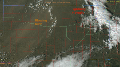
Kansas at 3p: Dust Storm and Lightning

Image
At 3pm CDT, lightning (small + symbols) and blowing dust (brown) are both occurring in Kansas -- a highly unusual situation.  Click to enlarge  I still believe we will see thunderstorms with damaging winds later. Please see the post below. 

Brown Moonlight and Brown Snow

Image
At 4:45am, an eerie brown moonlight was projected across Wichita. This was a result of blowing dust that was carried northeast from New Mexico and west Texas yesterday. The dust became more extensive as the afternoon progressed. New weather satellite technology allows meteorologists to track the dust (yellow) as the wind transported it northeast then north during the night. Here it is over Kansas. It then moved rapidly into the Upper Midwest where it produced brown snow in Minnesota.