
3:11pm CST Update: Dangerous Storm Forecast for Tuesday and Tuesday Night
From AccuWeather, here is an overview of the storm: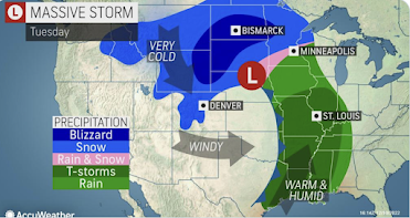 Note the word, "blizzard." The pink area is where the #1 hazard is an ice storm.
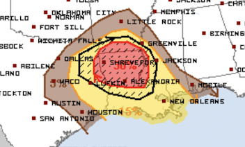 The yellow and red areas have significant and enhanced probabilities, respectively, of tornadoes and severe thunderstorms. The hatched area = strong tornadoes possible. It will be important to keep up on the weather in these areas.

 These are forecast radar images for 1pm Tuesday.
 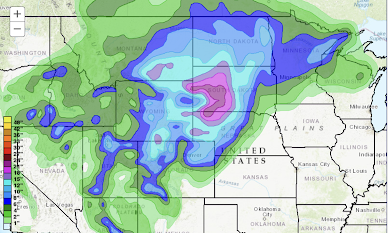 Extraordinary snowfall is likely. I'm forecasting more than 20 inches in southwest South Dakota. With the high winds, roads will be closed and/or impassible.

Let's break down the hazards.
Tornado and Severe Thunderstorm

Ice Storm and Power Outages
 |
| From Sperry-Piltz |
The freezing drizzle and freezing rain will develop Monday night and continue into Tuesday night. With increasing winds during the period, there is the possibility of power failures.
Heavy Snow and Blizzard


- Red and pink = freezing rain and freezing drizzle. Accumulating ice likely.
- Blue = snow, darker shades of blue = heavier snow. At that time, blizzard conditions will be occurring in northern Nebraska and the Panhandle as well as in South Dakota. The blizzard will move somewhat farther north later in the day.
- Green = rain; yellow = thunderstorms.
Snow Amount Forecast

I will update on this situation again tomorrow. It is vital that you factor these forecasts into your plans, especially if you are planning to travel on Interstates 80 or 76.


Comments
Post a Comment