Threat of Damaging Winds
We have another threat of severe thunderstorms in the central Great Plains late today and tonight.
Damaging Winds
The hatched area is where the NWS SPC is forecasting wind gusts stronger than 75 mph.
The yellow area has a significant risk of wind gusts of 60 mph or stronger.Tornado Risk
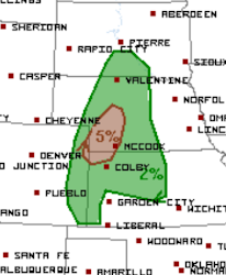
There is a small area of signifiant (brown) tornado risk in the High Plains of Nebraska and adjacent areas of Kansas and Colorado.
There will finally be a break after these storms tonight. However, next week we may get into a late-season tornado and severe thunderstorm situation in the early to middle part of next week.


Comments
Post a Comment