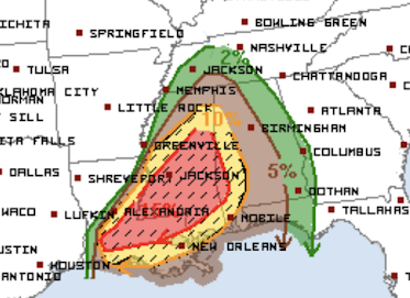
Tornado High Risk Moved North
The highest risk area (red) for strong tornadoes has been moved north a bit and the significant tornado risk (brown) has now been extended into far southwest Tennessee. This forecast is from the NWS SPC.
This is one of those conditional risk situations: if supercells develop, there is a high risk they will produce tornadoes that will likely be strong and long-tracked.
Please monitor local weather information in this area! I will supplement it with coverage on Twitter @usweatherexpert.


Comments
Post a Comment