
High Risk of Damaging Tornadoes, Winds and Hail Next 24 Hours. Updated, 11:30am
Let's begin with the headline, 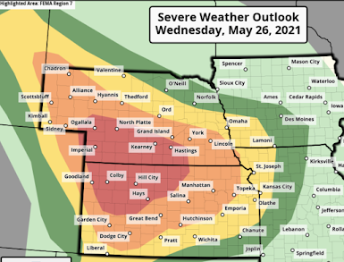 If you live in the red or orange areas, you need to plan for destructive weather -- now. I'll break weather forecast into its components below, but let's begin with recommendations:

I do have a concern that the yellow area may need to be dropped a little farther south into the Liberal and Pratt areas in Kansas. I'll update these forecasts early this afternoon.
 The yellow is where there is a significant risk of wind gusts above 60 mph. The hatched area is where they could gust above 75 mph. This certainly puts power failures -- perhaps extensive -- into play.
 Again, the yellow area is whee there is a significant risk of hail 1-2" in diameter. The hatched area is where hail larger than 2" in diameter is forecast to occur. Large hail driven by powerful winds can be very destructive.

- Make sure you have three independent means to get storm warnings. I used to say two but with the failure of both WEA and the sirens during the Selden Tornado Monday, make sure you have three. I would recommend the AccuWeather App, WEA, WeatherCall, or a weather radio. This is especially important since some tornadoes could occur after dark.
- Insure your sheltering area is ready to go: clean and clear, a couple of bottles of water, diapers, battery flashlight and radio or television. Wear shoes into your shelter area. If you have a bicycle or similar helmet, take it/them into the shelter area.
- Make provisions for infirm friends and relatives now.... Early in the day.
- Fully charge your laptop and smartphone but disconnect the charger before thunderstorms arrive (a power surge due to lightning could damage them).
- There is a real chance of power failures. So, go ahead and get extra cash at the ATM and fill your vehicle with fuel.
- With the above, if you want to purchase a portable generator, fine, but make sure you do not use it indoors or near windows or other air intakes.
- Whatever you do, if a tornado warning or extreme wind warning is issued, get into shelter immediately. Do not go outdoors to see it!
Now, the weather breakdown:
Tornadoes
Using my scale, the red area has a high tornado risk and the yellow area has an enhanced risk. The tornadoes should begin 3pm or after, Central Daylight Time.

The brown area has a significant risk. The hatching is where violent tornadoes are forecast to occur. Update 11:30am, NWS wisely pulled the hatching farther south and enlarged the 15% area.
Damaging Winds
The thunderstorms may congee into a squall line or even a derecho -- a line of very damaging winds.

Damaging Hail

There is also a risk of tornadoes and severe thunderstorms in the central and southern Great Plains and Ozarks region tomorrow. I'll cover that early this afternoon.


Comments
Post a Comment