A Taste of Winter on the Way
Use the relatively warm weather now to prepare for winter-like conditions throughout the Central U.S. by mid-week.
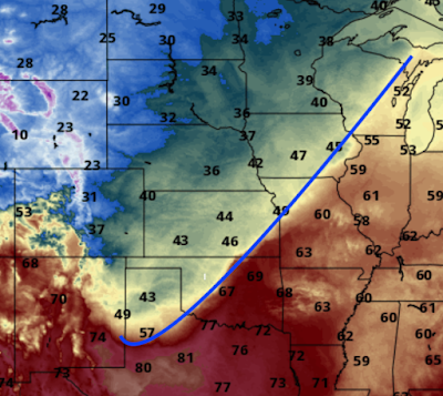
A major cold front will be moving through the nation the next couple of days and it will be huge changes in temperature.
The blue line is the position of the cold front as of 4pm Sunday. Note temperatures in the 20s of the northern High Plains.
By Monday afternoon, the slow-moving front will bring high temperatures in the 20's as far south as Kansas.
The consequence of all of this will be a cold and, possibly, snowy Halloween in a large part of the central United States. The green are is where the National Weather Service is forecasting accumulating snow from 7am Thursday to 7am Friday.
I'll update the forecast over the next couple of days.


Comments
Post a Comment