
Heads Up: Central Great Plains
There are serious weather risks to deal with this afternoon through tonight.
Tornado
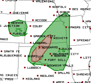 There is a significant risk of tornadoes in the brown area from Wichita and Hutchinson southwest through Woodward, Elk City, and Childress.
Damaging Winds and Hail
 The yellow area is a significant risk of damaging winds and hail. The red+hatching is a high risk of hail with sizes (in the hatching) larger than 2" in diameter.
Flash Flooding
 The yellow areas have significant risks of flash flooding. As much as eight inches of rain fell near Peabody, Kansas, last night which is an indication of what could happen tonight if thunderstorms move slowly.
There will also be a risk of severe thunderstorms and flash flooding tomorrow. I'll update tomorrow morning.
Tornado

Damaging Winds and Hail

Flash Flooding

There will also be a risk of severe thunderstorms and flash flooding tomorrow. I'll update tomorrow morning.


Comments
Post a Comment