
Heads Up: Eastern 2/5th's of Kansas
Here is the radar from 1:11pm CDT.
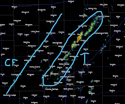 CF = Cold Front. T = area of thunderstorms. I've circled the areas where thunderstorms are now developing. They are moving northeast and pose a lightning risk.
I expect more thunderstorms to develop along and ahead of the cold front the rest of the afternoon. Remember, When Thunder Roars, Go Indoors!
There is a good chance that some of the Kansas storms will produce hail and strong winds. In south central Kansas, large hail and damaging winds are possible. There is an outside chance of a tornado. Please keep up with the weather the rest of the afternoon.


Comments
Post a Comment