
Winter Storm Update: 1:30pm CST
Here is an overview of the storm total amount of snow expected. Note that amounts have gone up a bit in parts of New England.
Here is the Boston-New York closeup. Note the extreme gradient between the coast (Logan Airport where 3-6" is expected) and areas farther inland and at higher elevations.

Here is the Washington-Baltimore closeup. Reagan airport will have 2-4 inches with higher amounts at Dulles.

Much farther south, these are the snowfall amounts expected to be on the ground at 9am EST Wednesday. I-40 will be a mess over the mountains. The storm will spread northeast during the day Wednesday.
 Again, my airline survival guide (free!) is here. If you can, take advantage of the waivers to beat the storm.
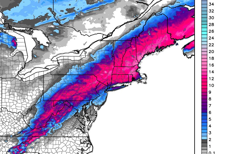
UPDATE: 3:10PM. Here are the warnings issued by local NWS offices. Pink is a winter storm warning. The bluish is a winter weather advisory (a lesser condition) for lighter amounts of accumulating snow.

Here is the Boston-New York closeup. Note the extreme gradient between the coast (Logan Airport where 3-6" is expected) and areas farther inland and at higher elevations.
Here is the Washington-Baltimore closeup. Reagan airport will have 2-4 inches with higher amounts at Dulles.
UPDATE: 3:10PM. Here are the warnings issued by local NWS offices. Pink is a winter storm warning. The bluish is a winter weather advisory (a lesser condition) for lighter amounts of accumulating snow.
Comments
Post a Comment