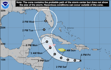
Likely Hurricane Ian Forecast to Move Into Florida Wednesday
Hurricane Watch for the Cayman Islands (pink) and Tropical Storm Watch for Jamaica.
The National Hurricane Center continues to move the forecasted point of landfall to the north. They now believe the most likely point of landfall is near Tampa Bay. Sustained winds are forecast to be 115 mph miles an hour, which is a Cat 3 storm.
However, it is still possible that the point of landfall could be anywhere within the white outline. Please prepare accordingly.


Comments
Post a Comment