Possible Tornado Outbreak Tuesday Afternoon and Night
Please see 9:55pm update (above).
-- original post below --
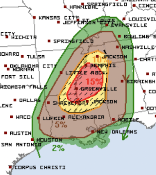
The above map depicts a tornado outbreak with the risk beginning around noon Tuesday through the pre-dawn hours on Wednesday. Here is what the map, from the NWS's Storm Prediction Center, forecasts using may 4-level scale:- Brown, significant risk of tornadoes.
- Yellow, an enhanced risk of tornadoes and the hatching indicates some of the tornadoes could be strong.
- Red, a high risk of tornadoes. The hatching indicates some could be strong.
Now, while the weather is still nice, is time to double check your tornado procedures and make sure your shelter area is ready to go.
Because there is a high risk of tornadoes during darkness, it is time to seriously consider StormWarn. For just $25 per year, you'll get a phone call 24 hours a day if you are in the direct path of the tornado but only if you are in the direct path. Unlike a weather radio, you will not be awakened for a forecast of hail 20 miles away. Nighttime tornadoes are more than twice as deadly as tornadoes during daylight. Please consider StormWarn. It may save your life.


Comments
Post a Comment