
How Did the Tornado Forecast Work Out?
As we usually do after a major forecast, here is an evaluation of the tornado forecasts for the event that was in progress 24-hours ago. 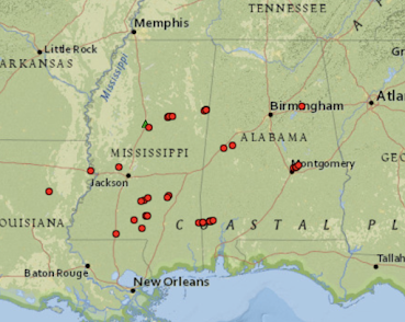 Above is a map of the tornadoes (red) reported, so far, which number 37. Inevitably, when the local NWS offices finish their surveys, there will be more. This is especially true since there were 83 reports of wind damage (blue, see map below). Some of those will be converted to tornado damage when the surveys are complete.
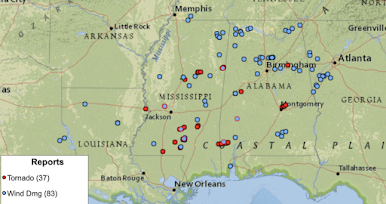
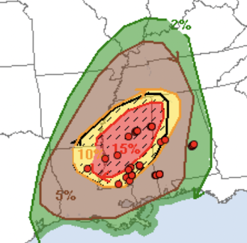 While the 15% was the maximum correct value, it was placed too far to the northwest. What may not have been correct was the hatching. So far, there have not been many reports of EF-2 or stronger intensity tornadoes. The 5% (brown) was way too far north.


Here is the SPC forecast for comparison. 

And, here are the tornado reports plotted on top of the forecast.

Still, this was -- overall -- a good forecast. I would give it a B.
The upgrade to "high risk" on my scale because of the tornadoes in darkness threat, was a good idea.
A lot of damage occurred in the South (see here and here, for example). Two fatalities occurred around 3:20am just north of Montgomery, Alabama. I have a concern that people in the area may not have realized the threat since the tornado watch was not issued until 10:50pm, which is after most retire. That is why I strongly encourage two passive independent methods of receiving a tornado warning. I say "passive" because I think it is important for it to be working the background regardless of whether the user is expecting tornadoes or not.
Two excellent choices, especially if you have a landline, are StormWarn (using the landline) and WEA (using your cell phone). Or, for extra security, StormWarn and a Weather Radio.
ADDITION:
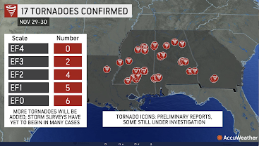
This is the preliminary tally of surveyed tornadoes by EF-Scale.


Comments
Post a Comment