High Tornado Danger This Afternoon and Tonight in the South
A Day Where it is Essential to Monitor the Weather
Life-threatening, destructive tornadoes are likely to occur.
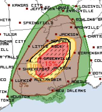
The above map from the NWS SPC depicts a tornado outbreak with the risk beginning around 1-2pm today through the pre-dawn hours on Wednesday. Here is what the map, from the NWS's Storm Prediction Center, forecasts using may 4-level scale:
- Brown, significant risk of tornadoes.
- Yellow, an enhanced risk of tornadoes and the hatching indicates some of the tornadoes could be strong.
- Red, a high risk of tornadoes. The hatching indicates some could be strong.
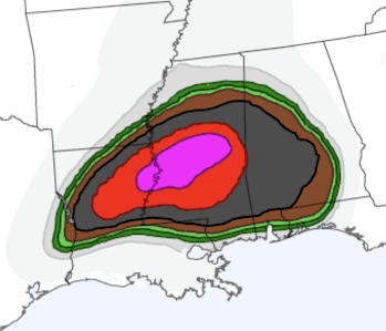
To better narrow down where the highest risk of destructive tornadoes exists, consider the experimental map below. It depicts the probability of strong and violent tornadoes.
 |
| @nadocast on Twitter |
The red and purple areas are at very high risk of strong tornadoes.
Now is time to double check your tornado procedures and make sure your shelter area is ready to go. Also, make sure you have at least two independent methods of receiving tornado warnings.
Because there is a high risk of tornadoes during darkness, please seriously consider StormWarn. For just $25 per year, you'll get a phone call 24 hours a day if you are in the direct path of the tornado but only if you are in the direct path. Unlike a weather radio, you will not be awakened for a forecast of hail 20 miles away. Nighttime tornadoes are more than twice as deadly as tornadoes during daylight. Please consider StormWarn. It may save your life.


Comments
Post a Comment