
Regarding the Overnight Tornado Situation in the Kansas City Area
 |
| Johnson Co. Kansas tornado damage Photo by my brother, Mark Smith |
Then, came the utterly botched Joplin Tornado in May, 2011. Not only was the warning botched (with a death toll of 161 -- far higher than it should have been), the post-storm report was either incompetent or a coverup. Regardless, the National Weather Service (NWS) seemed to institutionally lose confidence in its own excellent program. The "fixing something that didn't need fixing" combined with the retirement of my generation of meteorologists (who had the experience to ignore the nonsense and issue a quality warning anyway) has caused the quality of tornado warnings to dangerously decrease. It isn't just my opinion that the warnings have gotten worse, the NWS's own statistics confirm that is the case.
Since then, the issues have piled up. In just the last three weeks:
And, early this morning, an EF-1 intensity tornado moved across 14 miles of Johnson county, Kansas. The tornado was warned of later than it should have been because the Kansas City office of the National Weather Service had its radar on the wrong setting. There is a second Doppler weather radar in the area, the Federal Aviation Administration's Terminal Doppler Weather Radar (known as TMCI) but it was down for maintenance (during tornado season!).
While the Johnson county tornado was relatively minor as tornadoes go, given the radar situation, it wouldn't have mattered if it was a weak tornado or a monster like Joplin: no radar data means no tornado warning!
The first indication of a tornado in Johnson Co. was at 1:10am when a rotational couplet (not shown) developed over Lenexa. It produced lofted debris. This should have prompted a tornado warning.
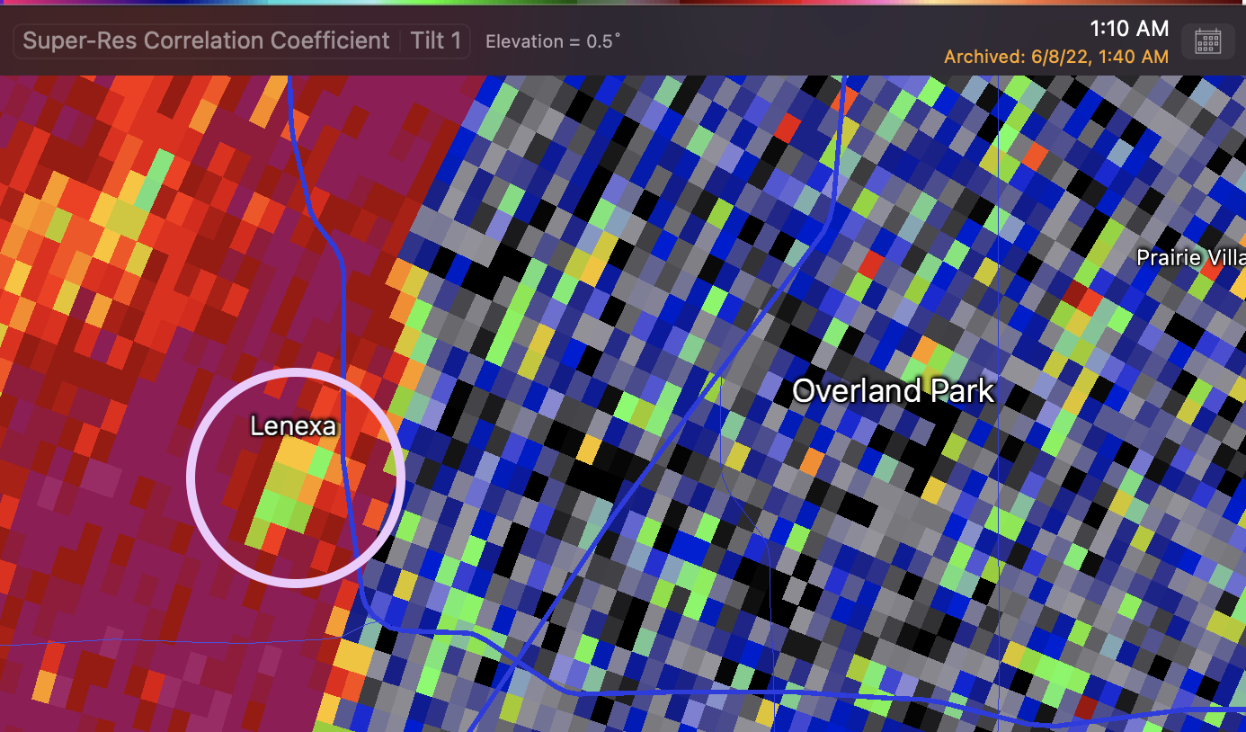 |
| Lofted debris (lowered dual-polarization correlation coefficient) circled |
Unfortunately, since the radar was on the wrong "volume scan" (#215) which was producing data at just 6-7 minute intervals, the next data wasn't available until 1:17am -- after the storm had traversed through six miles of dense population.
At that time, the radar operator correctly switched to scan #212 with the SAILS (tornado detection) feature which provides data at about 1.3 minute intervals. The 1:17am data was ambiguous but by 1:19am there was a clear signature of lofted debris.
%20LOFTED%20DEBRIS.png) |
| Lofted debris at the intersection of 95th and Metcalf |
 |
| City of Overland Park traffic camera with an image of the tornado as moved east along 95th Street east of Metcalf |
Here is the issue: With no data available from 1:10 to 1:17, it wouldn't have mattered if it was a weak tornado like this or a major tornado like a Joplin or Greensburg -- no warning could have been issued unless a trained spotter happened to see a funnel and called it in during the middle of the night. This scenario was unlikely as there was no tornado watch, so spotters would not have been active in the manner they would have during the day with a tornado watch in effect. As it is, there are 67,000 homes and businesses without power in the region. That is illustrated by the map below.

Even worse, when the tornado warning was finally issued many phones' Wireless Emergency Activation did not trigger. This troubled government program needs to be fixed or put out of its misery.
Given the radar strategy issues, the radar out at KCI, and the problems with WEA, Kansas City was very lucky.


Comments
Post a Comment