
3:15pm Update: Tornado and Damaging Wind Forecast
The forecast from the NWS SPC has changed a bit since this morning.
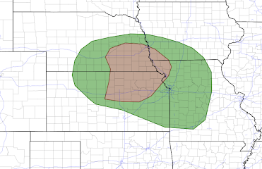 The tornado risk has been pulled a bit to the west and now includes Omaha, Lincoln, St. Joseph, Topeka, Manhattan, Salina and Concordia. If tornadoes occur, it will likely be in the 6pm to 10pm period.
Tornado Risk

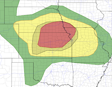
Damaging Wind Risk

The more widespread threat is damaging thunderstorm winds. The red area has has been enlarged to the west in Kansas. I would put the car inside this evening and bring in trampolines, lawn furniture and other items that can blow about. Do it now, before the storms develop, if you live in the red area.
- The hatched area is where wind gusts of 75 mph or stronger are forecasted to occur. In this area, power failures and toppled trees are likely if the winds reach forecast values.
- Non-hatched areas are where winds of 60-75 mph are forecasted.
- The red area has an enhanced risk of those winds occurring.
- The yellow area has a significant risk of those winds.


Comments
Post a Comment