
UPDATED: Tornado and Damaging Wind Forecast
This forecast is from 3pm today to 7am tomorrow (Tuesday).
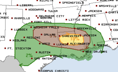 The brown area has a significant risk of tornadoes.
Tornado Risk

The yellow area has an enhanced risk of tornadoes. Unfortunately, the forecasted tornadoes in the yellow area are forecasted to occur after midnight. It is vital you have more than one way of receiving a tornado warning while you are sleeping.
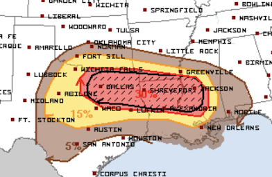
Damaging Wind Risk

The red area has a high risk of wind gusts of 60 mph or stronger. The hatched area is where wind gusts of 75 mph or stronger are forecasted to occur.
The Bottom Line
It is absolutely essential you prepare for power outages and toppled trees.
- Make you have plans for the elderly or infirm family or friends. You may want them to spend the night with you if you are in the highest risk area.
- Have WEA active on your smartphone.
- Know where to go at a moment's notice if a tornado warning is issued.
- If you live in a mobile home, go elsewhere if wind gust of 70 mph or stronger are the topic of a severe thunderstorm warning.
- Fully charge your laptop and smartphone this afternoon.
- Fill your car with fuel today.
I will update again this afternoon.
Also....
There is an enhanced risk of tornadoes in the South Tuesday and Wednesday. I'll have more on that later in the day.


Comments
Post a Comment