
Updated Long-Range Tornado and Severe Thunderstorm Outlook
Based on later data and model simulations, I've enlarged my potential tornado and severe thunderstorm* forecast. It is valid from noon Monday until 6am Thursday.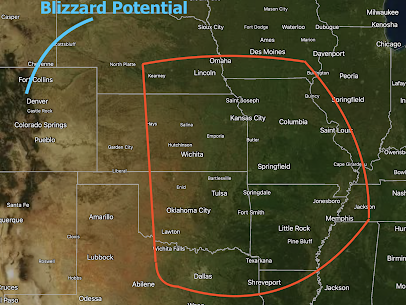

Just as a note: I am especially concerned about Tuesday in the central Great Plains. Based on preliminary indications, tornadoes with supercell thunderstorms may occur in parts of NE-KS-OK.
There is also the potential of a severe blizzard in the Dakotas with blizzard conditions farther to the southwest. This should definitely factor into your travel plans. I will post a comprehensive blizzard outlook tomorrow.
Recommendations
Schools: If you haven't recently had a tornado drill, Monday tomorrow would be a good day. Make sure everyone is familiar with tornado procedures and ways to protecting everyone involved.
Business: See above, plus make sure you have ways of instantly notifying employees working outdoors.
Homes: Make sure your shelter area is clean and ready to go. Put a couple of bottles of waters, old pairs of shoes (you don't want to walk out barefoot if a tornado strikes) and, if appropriate, a couple of diapers in your shelter.
Everyone: Have at least two reliable ways to receive emergency storm warnings. One of them should be Wireless Emergency Alerts.
*The definition of a "severe" thunderstorm is hail one inch or larger or 60 mph, or stronger, thunderstorm wind gusts.


Comments
Post a Comment