11:05pm Thursday: Full Update on Tropical Storm Hurricane Ida
Please click here for the 4:30pm Friday update.
-- original posting --
Hurricane Threats
The National Hurricane Center's "cone" forecast is below.
 |
| 10pm cone forecast. Hurricane watch is in pink. Yellow is the tropical storm watch. |
A guide to the "cone" map is below.
It should be noted the Hurricane Center is forecasting wind speeds at landfall just 1 mph below Cat 3 status.
It should be noted the Hurricane Center is forecasting wind speeds at landfall just 1 mph below Cat 3 status.
The new U.S. Global Forecast System model forecast is in and it is consistent with the National Hurricane Center's forecast.
It depicts a 117 mph hour sustained wind hurricane approaching the Louisiana coast Sunday afternoon. Below is the time by which your preparations should be completed -- the time sustained winds rise above 40 mph.
In addition to the threat from the wind from a major hurricane, there could also be a major -- life threatening -- storm surge plus tornadoes. National Hurricane Center's initial storm surge forecast is below. It does not include tides nor waves.
The Major Inland Flood Threat
If this forecast is correct there will be widespread, catastrophic flooding in the South.
If this forecast is correct there will be widespread, catastrophic flooding in the South.
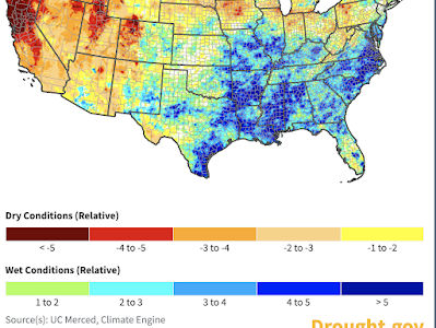
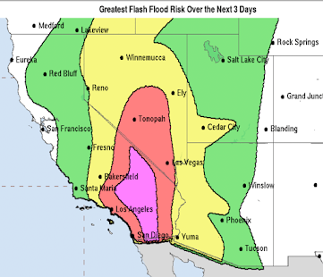
One of the reasons Saturday's Tennessee Flash Flood was so severe was because the ground was already wet as shown below. Most of the path of the forecasted 5+ inches of rain is even wetter than mid-Tennessee. It is essential that you prepare for flooding if you are in an orange --> amber --> yellow area depicted above as some areas will see rivers at record levels!
What would I do now if I were living in this area?
- Contact infirm friends or family in the region. Come up with a plan to protect them should they be placed in a hurricane warning (~24-30 hr before landfall). This especially applies if an evacuation is ordered. Don't wait until the last minute when rooms may all be reserved! Insure they have appropriate transportation in an evacuation.
- Get prescriptions refilled NOW! Don't wait for the weekend.
- Make a hotel reservation well inland. However, make sure you can cancel it at no charge. If it turns out you don't need the room, be courteous the cancel the reservation. This way, you'll have a nice place to stay, if needed. It also frees up the shelters for people who cannot afford hotels. Because of the flooding threat, I might recommend Sheveport or even Dallas.
- Figure out what you can fit in your car in the way of irreplaceable items like scrapbooks and family heirlooms.
- Make sure you have at least three ways of receiving vital warning information.
- Prepare for power failures. If you have a generator, fill it with fuel. Do the same for your car. If you want a generator, have a professional install it.
- Get extra cash at the ATM. Credit cards don't work if the power fails.
- If you have a chain saw, fill it with fuel.
- Clean out gutters.
- Install your hurricane shutters or board up windows.
- Before you leave, turn off water at the main valve and turn off electricity at the master switch.
Please make your friends aware of my these postings along along with my Twitter account @usweatherexpert.
This is my last update of the night.


Comments
Post a Comment